
Walking on the Canary Island of La Gomera? Updates December 2014

On La Gomera – Tenerife’s Teide visible
Winter is a great time for walking in the Canary Islands. La Gomera is easily reached yet remains wild and natural with breathtaking scenery and the winter weather is usually fresh yet gentle, with plenty of blue skies; though there can be periods of rain it rarely lasts for long.
We thank Pamela and Malcolm Boura for these useful and detailed notes they made on their visit there this December; they were using the guidebook Walk! La Gomera and La Gomera Tour & Trail Map.
All of the new paths and those missing from your map, referred to below, are shown correctly on OpenStreetMap. You may need to use an editor to look at some of the tags for detailed information such as tarmac/unpaved.
Walk 1
Start of walk: OpenStreetMap shows a path running from a little way down the path to La Laja to Wp2. We did not walk this but the west end looks good and it looks clear on aerial photographs. It probably provides an alternative to the road. According to some rather uncertain contours, it adds about 30m of ascent.
Easy route first paragraph: new path avoiding buildings and noisy dogs to Wp5, see OpenStreetMap. Adds a few metres of ascent but is shorter and is the signed route.
We walked the first part of Walk 1 as the start of Walk 2.
Walk 3
If the start of this walk is not in La Laja, part of the descent to and ascent from the village can be avoided by taking a good donkey path, with fine views of the village, which starts as you cross the spur after Wp16 and emerges to rejoin the main route at the last houses of La Laga, where the sculptures are, after Wp2. This good and useful path is not shown on your map. See OpenStreetMap.
Walk 8
We think this walk should be done in reverse with the steeper and rougher paths as ascent and then the long, fast, gentle descent for the return. Climbing up Barranco do los Cocos would also be much safer than going down, especially in rain, as well as giving a better opportunity to appreciate this lovely valley.
The start of this walk in Playa Santiago has changed after recent works on the river bed. Now follow the east bank until scrambling up the road embankment at the end of the track at Wp2. The first zig and zag are tarmac. Alternatively, parking is available at the adjacent rest area.
There is a clear signposted path branching left before Wp7 which leads directly to the new wooden bungalow. This avoids the final part of the climb towards Targa and the short length of road. This good and useful shortcut is not shown on your map.
Walk 22
The track up Barranco del Valle Gran Rey at present can not be accessed from the lane which starts behind the bus station. This may be temporary.
Walk 23
We walked this in reverse and the start in this direction is confusing and needs instructions. Suggest “A few metres after leaving the road, head right up some rough rock cut steps.”
Walk 25
Some of the “path” is washed away crossing the gullies between Wp2 and Wp3. OpenStreetMap shows a path directly from the start to Wp6 which may provide a better alternative.
Just before reaching the road at the top of the barranco, the path goes to the north of the summit. This is not obvious on the ground and it is shown incorrectly on your map. The route shown on your map goes across a steep and dangerous hillside. See OpenStreetMap.
At Wp17, go slightly left across the road to a painted waymark on the crash barrier. The path from there goes directly to the cemetery.
Taking the alternative route in the last paragraph on your walk, turn right down a track just before the dirt track reaches the road. When the track reaches the bamboo, turn left on an overgrown but passable path to emerge on the road where the path entrance is marked by a cairn. NB This is a new road not shown on your map.
See OpenStreetMap for the extra paths and roads.
Walk 29
We very much enjoyed this straight forward walk but where the track junction is shown on your map between Wp7 and Wp8, we took the track forking left which continues as a good signposted path running parallel to your route but avoiding the road. This leads directly to the saddle between Mt Bianca and the masts and then along the ridge to the masts. See OpenStreetMap. We saw the ends of paths that probably bypass the masts to the NE, cutting the corner.
There is a signposted junction to the west of Wp8, at N28 10.802, W17 17.708, but the signpost has been sited sufficiently far from the junction (a few tens of metres east) to be misleading, especially if doing the walk in reverse. This needs checking on the ground before more can be said, as there were signs of a rough path north from the signpost, although I suspect that was due to people that had been misled!
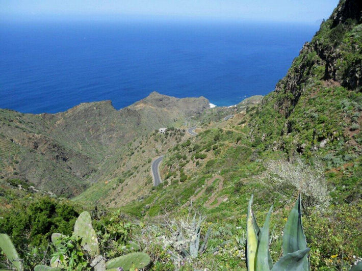
La Gomera – on Walk 31 (from Walk! La Gomera by Charles Davis). Image courtesy of ‘Inspire Our Trip’.
Walk 31
Unfortunately, the dirt track up Barranco de la Palmita has become a tarmac lane for much of its length. See OpenStreetMap for details of which bits (you may need to look at the editor information to get details of the surface).
