
Who got a Garmin for Christmas?
If you are one of the many who found a Garmin GPS in their Christmas stocking, this post is for you.
Get your hands on a free sample ‘real-time’ map and see your Garmin come to life. You can choose a sample map of Graciosa ( off Lanzarote, Canary Islands) or Sierra de Aracena (Andalucia, Spain).
What you’ll get is a highly detailed real-time Tour & Trail digital download map, which you can save on your hard drive, transfer to your Garmin GPS CustomMap memory or onto a micro-SD card; you can also use the maps in Garmin Basecamp and Google Earth.
CANARY ISLANDS
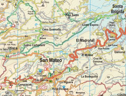
Sample segment, Gran Canaria.
Gran Canaria
Tenerife
La Palma
La Gomera
Lanzarote
Fuerteventura
MAINLAND SPAIN
Alpujarras (Sierra Nevada, Andalucia, southern Spain)
Costa Blanca Mountains (Alicante, southern Spain)
Axarquia (Andalucia, southern Spain)
Sierra de Aracena (Helva province, southern Spain)
BALEARIC ISLANDS
Mallorca
Menorca
Formentera
Ibiza
PORTUGUESE ISLANDS
Madeira
For more information about Tour & Trail Maps take a look HERE.
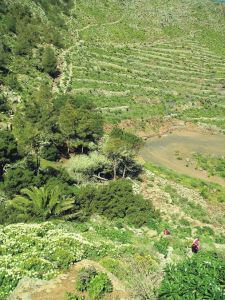
Madeira – news just in – Levada Nova
Thanks to Peter and Ginny, just back from a walking holiday on the isle of Madeira, we are passing on their update:
“Levada Nova has had rock falls along an extensive section near the start so that virtually all the safety barriers have disappeared. This makes the walk dangerous! We tried to carefully continue thinking the damage would be limited to a short section but it seemed to go on for a long distance so we turned back.”

Levada Nova, Madeira (Walk 73)
Levada Nova is a popular walking route; if you are using Madeira Walks Volume Two, it is Walk 73.
Do check before setting out, either by asking at Tourist Offices or by looking on the island’s official website walking pages.
Are You Off To Walk Madeira? Check Before You Walk.

Aloe aborescens clinging to Madeiran cliffs
Madeira! What a great desination, especially at this time of year.
Swapping the dark and cold of Northern Europe for Madeira’s green and spring-like mountains is a popular choice at this time of year.
If you are planning to walk there, it’s worth checking that the paths you’re planning on following are open. The best place to look for information is on the official ‘Visit Madeira’ tourism website. To see which routes are open or temporarily closed, LOOK HERE.
If you are already on the island, you can also ask in Tourist Offices who usually have up to date information on walks that are open/closed.

A spectaculat waterfall on the Levada da Ribeira da Janela
At the moment only three of the official routes are temporarily closed. The authorities are vigilant and usually restore routes quickly; often, the problem is a landslip after heavy rain.
The three routes to avoid at the time of writing this are:
PR1 – Vereda do Areeiro
Temporarily closed
PR12 – Caminho Real da Encumeada
Temporarily closed
PR19 – Caminho Real do Paul do Mar
Temporarily closed

Levada Nova, Madeira
There’s so much great walking on Madeira that you’ll find plenty to tempt you, from strolls to all-day high altitude challenges. Even if you aren’t keen to do much walking, it’s a great idea to use the local buses which give you brilliant (sometimes a bit hairy!) adventures around the island for pocket-money prices.
There’s a great bus map available, also really useful as a driving map; LOOK HERE for details of the Madeira Bus & Touring Map.
For more information including details our two Madeira Walks guidebooks Madeira Tour & Trail Map and digital mapping for Madeira, take a look at Discovery Walking Guides; Madeira pages.
Christmas Calories? Walk them away!
You’ve probably seen at least one news report in the days leading up to December 25th, scaring your socks off revealing your likely calorie intake for Christmas Day. It seems that consumption of 6000 calories on the Big Day is quite usual. This is according to the Royal Society for Public Health in the UK.
Here’s one of the newspaper reports.
When you’ve enjoyed all those goodies, what next? Given that one report suggests that you might well gain 26 stone or 165 kilos in one year (gulp!) if you ate like every day was Christmas, something’s got to give.
One report claims you would need to do 21.5 hours of walking, 13 hours of aerobics or 7.5 hours on a treadmill to use up that one festive day’s intake. Okay, let’s get real. That’s not going to happen for almost all of us.
Why not take an hour’s brisk walk (using about 375 calories) for starters? Deciding on achievable targets (keep them fairly small and reasonably regular) means you’ll get the satisfaction of ticking off a walk well done and you’ll feel more positive about keeping it going. There are multiple health benefits that come with taking a regular walk.
Walking For Health’s website is useful and inspiring if you want more reasons to get walking.
Taking a break or holiday which includes the opportunity to explore on foot will up your walking while you enjoy new surroundings and experiences.![]()
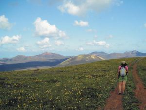
Lanzarote; rains bring the desert to colourful life!
Barranco del Malpaso, Lanzarote
Residents on the Island of Lanzarote tell us that more visitors than usual have been enjoying the great outdoors on this unique island during November and December this year. The dramatic volcanic landscape is unforgettable, though is usually desert-dry with little natural green to see.
It doesn’t rain much (or often) on this arid Canary Island, so recent falls have been most welcome, bringing colour and plant life back to otherwise arid areas.

Helechos, Lanzarote
What a great time to visit! Warm days and sunshine (average of six hours per day in December, even more in January), plus the chance to see the colourful green swathes and flower carpets that happen for only a few weeks each year. Walk, hire a bike or car, or jump on a bus.
La Geria, Lanzarote
There’s plenty of interesting information about the island on the Lanzarote Information website; use the link below.
Take a look at the really useful Lanzarote Information website.
For more on this fascinating and often surprising island, including printed and digital mapping and walking information, take a look here:-
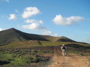
Montaňa Corona, Lanzarote
Beaches, Snow-Capped Mountains and Wonderful Walking – has to be Tenerife

Majestic Mount Teide, Tenerife
One of the great things about Tenerife is that you can enjoy the snow-capped peaks in the morning and have time to watch the sun go down from a warm, sunny beach that same day.
If you like lively resorts, Tenerife has them; if you prefer quiet settlements and small towns, you’ll find plenty of choice also.

Tenerife Bus & Touring Map
The bus service on the island is pretty good. If you have to drive while back in your ‘real life’, it’ll be so relaxing to discover Tenerife by bus.
If you want to drive, there are car hire companies galore.
And the walking – it’s varied and surprising. If you fancy country strolls or want to scale the mighty Mount Teide (or anything in between), Tenerife will not disappoint you.
Tenerife’s south is drier than the north, mostly due to massive Mount Teide dominating the island’s centre and affecting the island’s micro-climates.
Teide stands above the vast volcanic peaks and plains of Las Cañadas. The easy way to get to this highest point on Spanish territory is via the exciting cable-car ride. On A clear day you’ll see for many kilometres with fine views of some of the other Canary Islands.
The verdant north includes the capital of Santa Cruz, home to some fine old buildings and modern shopping. One of the original resorts, Puerto de la Cruz, sits on the north coast with plenty to
occupy visitors. Further west along the coast lies the ancient settlement of Garachico. It’s a fascinating old town with an unusual black natural rock-pool coastal area and a swathe of petrified lava remaining from Mount Teide’s eruption in 1706.

The Anaga, Tenerife
To the north-east is the wild area of Anaga, a walker’s delight.

Masca, western Tenerife
Dramatic and extreme geology on the west coast makes for plenty of ‘wow’ factor. The tiny settlement of Masca has to be seen to be believed though only drive yourself there (and back) if you have nerves of steel and no fear of narrow, winding mountain roads.
Los Gigantes is farther down the west coast, a larger and more modern settlement with a huge vertical set of cliffs plunging seawards with a narrow beach at their feet.
Inland from the west coast are walking paths and small settlements far from the tourist crowds.

Inland from Tenerife’s west coast
The sun-baked south of the island offers wide choices of accommodation, beaches, night-life, sports facilities and shopping. There are also some great walks in this region too. For more information about the island of Tenerife take a look at Discovery Walking Guides’ website
There’s a brand-new edition of the highly recommended Tenerife Hikers’ Maps, out now. Find out more by clicking HERE.

Tenerife Hikers’ Maps (3rd Super-Durable edition)
