
OSlike Custom Maps For Garmin – all Lake District
The final map in the four-map series of OSlike Custom Maps for Garmin is now available to download. See http://www.dwgwalking.co.uk/garminOSlikemaps.htm for full details and how to buy.
Walk Around The Malverns – a change to Walk 25
Author/researcher Bob Greaves has re-walked a section of Walk 25 ‘Old Storridge Green’ to resolve an access issue:-
From: Bob Greaves, researcher and author of Walk around the Malverns.
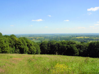
Old Storridge Common
The gate at Wp.14 now has a sign ‘Private No Public Right of Way’ so the route is blocked. This is such a shame as this has been a through route for decades, maybe even centuries; you will see that I actually describe it as ‘an ancient way’ in the text. However that doesn’t guarantee that it’s a public right of way!
There is a straightforward alternative which is to follow the ‘Geopark Way’ from Wp.12 to Wp.16,
unfortunately not so attractive and missing out on the ‘North Hill from Birchwood’ view. An alternative description might be:-
“….up a beautiful, sun-dappled track through woodland. Where a footpath crosses ours we turn right and follow the frequent signposts for the ‘Geopark Way’, out of woodland and up the left hand side of a couple of fields. With orchards and the courtyard development we passed earlier down to our right we turn left up a track back into woodland.
Out of the woods the path, smaller now, is through long grass to an updated black and white farmhouse. We skirt this anti-clockwise following yellow paint daubs then head straight on between fences to a lane. Here we have a brief opportunity to look across Birchwood Common before turning right. Finishing our dalliance with the ‘Geopark Way’, where the lane swings left and a track goes straight on……”
Bob
More information on Walk! Around The Malverns can be found here: http://www.dwgwalking.co.uk/malverns.htm
Isle Of Wight OSlike Mapping for Garmin Ready Now
 Just completed – OSlike mapping, Isle Of Wight, for Garmin users.
Find more information about OSlike Maps take a look at http://www.dwgwalking.co.uk/garminOSlikemaps.htm
Treat yourself to quality OSlike Custom Maps for your Walk! UK adventures with Garmin gps units
25k scale OSlike detail with all Walk routes highlighted, numbered and arrowed. £3.99.
Easy to load onto a microSD card to clip into your Garmin* so you have OSlike mapping on your gps.
The mapping works with any guide book though we recommend ‘Walk! The Isle Of Wight which details 40 varied routes. More information here http://www.dwgwalking.co.uk/isleofwight.htm
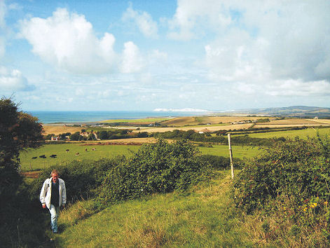
On the island’s south coast
Here’s your glorious view (right) while on Walk 19 Chale Bay.
The Isle Of Wight Walking Festival (3-18 May 2014) gets more popular every year.
If you want to be part of it, their official brochure can be viewed here:- http://tinyurl.com/ow6mp3s
But if you want to avoid big crowds of walkers and visitors, it might be better to go outside these dates.
NEW OSlike Maps For Your Garmin GPS – Don’t Miss This
 Hot off the hard drive!
OSlike maps are a new concept in digital mapping for Garmin GPS users.
The latest maps, for the beautiful Lake District, UK cover the area’s north-west, north-east and south-east.
They’re not only detailed maps – walking routes are included.
Treat yourself to quality OSlike Custom Maps for your Walk! UK adventures with Garmin gps units*
25k scale OSlike detail with all Walk routes highlighted, numbered and arrowed.
Easy to load onto a microSD card, to clip into your Garmin* so you have OSlike mapping on your gps.
Just £3.99 for each OSlike Custom Map for great value quality mapping.
Free Sample Map to Try before you Buy in Google Earth, Garmin Basecamp and in your Garmin. For ‘Try Before Your Buy’ look here http://www.dwgwalking.co.uk/garminTryB4Buy.htm
Take a look here http://www.dwgwalking.co.uk/garminOSlikemaps.htm
