
Madeira – getting out and about around the island
 Madeira is a beautiful, rugged island. It takes a bit of nerve to drive there if you’re a visitor and unused to the steep, narrow mountain roads and the spirited driving of some of the residents. It’s far more relaxing to take a bus and let someone else take care of the driving for you.
If you still prefer to drive yourself, you need a clear and up to date map. Newly published is the 6th edition of Madeira Bus & Touring Map, the ideal travelling companion for drivers and bus users.
Discovery Walking Guides ENews

Breathtaking views on the island of Madeira.
Take a look at our latest ENews featuring Ibiza, Formentera, Corfu, Madeira and Dartmoor.

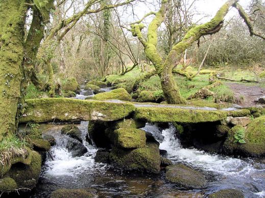
Dartmeet stepping stones
Ibiza! Formentera!

Ibizan sunset
Hot off the press are two great new maps, highly detailed and just the thing whatever you want to do on this lovely isle; bikers, hikers and beach-lovers will find just what they seek on Ibiza and its little sister, Formentera.
There’s a special offer on for either (or both) maps :-

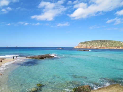
Just one of Formentera’s perfect beaches
Dartmoor – discover the magic

Devonport Leat
Dartmoor – a place of history, myths and legends.

Blackingstone Rock (Walk 22)
The best way to experience its wild and wonderful moors and ancient stone villages is on foot.
Dartmoor residents and author-researchers Kate & Alan Hobbs know the moors well and are your step-by-step guides through forty wonderful walks, strolls and adventures. They know the best places to call in for a pub lunch along the route too!
Detailed walk descriptions, Ordnance Survey mapping and waypoints at decisions points, along with frequent timings, ensure you’ll find your way.

Dartmoor Ponies
Each walk is illustrated with photos taken along the route. Walks are graded for difficulty, distance, time required, ascents and descents and refreshments.

Walk! Dartmoor (2nd edition) arrives on the planet 18 January 2016.
For more details look HERE.

Dartmeet Stepping Stones (Walk 36)
Formentera? Where’s that? UPDATE
You’d be forgiven for not knowing the location of this little gem of an island. It’s surprisingly easy to reach and has a delightful personality all its own.
Formentera is one of the Balearic Islands to the east of mainland Spain, in the Meditteranean. It’s the little sister island to Ibiza and is only a 30-minute ferry trip away.
Here’s a few facts and figures:
- Beaches, beaches – so many of them for such a small island and white, clean and beautiful.
- The island had been occupied by the Carthaginians, then the ancient Romans, the Visigoths, the Byzantines, the Vandals, and the Arabs.
- Eventually the island added to the Crown of Aragon and later became part of the medieval Kingdom of Majorca.
- The main island of Formentera is 19 kilometres (12 miles) long and is located about 6 kilometres (4 miles) south of Ibiza in the Mediterranean Sea.

San Francesc, Formentera
- The major villages are Sant Francesc Xavier, Sant Ferran de ses Roques, El Pilar de la Mola and La Savina.
- Formentera comprises one municipality, also called Formentera, and has a population of 9,962 (as at 1 January 2010).
- Its land area is 83.24 square kilometres (32.1 sq mi).
- Cars are easily hired in the port and there’s a good choice of conventional or electric vehicles. There are more electric vehicle charging points here than anywhere else in the world, given its land area.
- Mopeds and bicycles are available to hire; the terrain is mostly flat and there are dedicated cycle lanes in some areas.
- The island has four Martello towers.
- Ferries to Formentera from Ibiza operate every half hour in high season.
- A local Ibizan (eivissenc) variant of the Balearic dialect of the Catalan language is spoken in Formentera though English and other European languages are frequently heard too.
Discovery Walking Guides carried out an intensive cartographic survey on Formentera a few weeks back and design of the new Formentera Tour & Trail Super-Durable Map is well under way.
For full details about the new Formen tera map, click here.
KICKSTARTER PROJECT
How would you like to be part of the launch of this exciting new map project? For a modest pledge you can help this project to fly – and receive free maps too.
There’s still time to be a part of this exciting project.
Take a look at DWG’s Kickstarter Project here.
Ibiza – white beaches, azure seas, verdant pine forests UPDATE
Forget the tabloid image of all-night clubbing, loud music and young visitors in various states of inebriation and undress.
The real Ibiza is a beautiful place, blessed by a wonderful climate with many hours of sunshine each month.
Numerous fine white beaches and little coves tempt the swimmer and sun-worshipper, while walking/biking trails meander through wild flowers underneath a canopy of fragrant pine woods.
A few Ibizan facts:
- Ibiza is one of the Balearic Islands, in the Mediterranean east of the Spanish mainland.
- It’s a naturally beautiful island with white sand beaches, turquoise seas and verdant pine woods, olive groves and wild flowers.
- The island has a long history of invasion by various forces including the Ancient Romans, the Vandas, Byzantines, the Moors, the Norwegians and were finally claimed by Spain. Nowadays, the ‘invaders’ are tourists.
- Ibiza is 572.56 square kilometres (221.07 sq miles) land area.
- The highest point of the island is Sa Talaiassa, at 475 metres (1,558 ft).
- The population is estimated at approximately 132,500.
- Eivissenc, a dialect of Catalan, is spoken on Ibiza, as is Spanish. English is widely spoken in tourist areas.
- Though renowned for its clubbing scene, there are beautiful beaches, pine woods and walking/biking routes across the island.
One of Ibiza’s beautiful coves (on the west coast)
Until now, the maps available for the island of Ibiza have been basic and without the kind of detail you need to enjoy exploring.
That’s all set to change as Discovery Walking Guides has completed their ‘on the ground’ mapping survey. Design of the new Ibiza Tour & Trail Super-Durable Map is well under way.
Click HERE for all the details of the new Ibiza map.

KICKSTARTER PROJECT
How would you like to be part of the launch of this exciting new map project? For a modest pledge you can help this project to fly – and receive free maps too.
There’s still time to part of this exciting project.
Take a look at DWG’s Kickstarter project here:
La Palma – the World’s Steepest Island

Walk! La Palma – new 3rd edition
Authors: Charles Davis and Jan Kostura
ISBN 9781782750215 £12.99
La Palma is the most north-westerly and the steepest of the Canary Islands; arguably it’s the steepest island in the world.

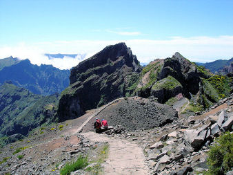
Views to Pico de la Nieve (Walk 29)
If you’re looking for a walking destination that’s wild, beautiful and unforgettable, La Palma will not disappoint.
Here’s a sample map section; there’s one for each of the 37 routes, along with full walk descriptions, photographs and GPS information.

Pico Birigoyo, Cumbre Vieja, La Palma (Walk 7)

For more information about Walk! La Palma and the companion La Palma Tour & Trail Map see Discovery Walking Guides’ website.
Dartmoor News – New research shows Sittaford Tor as Old as Stonehenge
 Did you see this interesting article in the Telegraph yesterday, 16 May 2015?
Dartmoor has a long and fascinating history; this new research suggests that some areas have an even longer history than was previously understood. See for yourself – take the walk.
The weather is perfect now for exploring British walking. If you want to take a look at the ancient stone circle of Sittaford Tor then follow Walk 9 in Walk! Dartmoor. The walk is a pleasant three and a half hour circular route which includes plenty of interest including the Tor.
For more information see:-
Madeira: The Garden Isle – a new walking guide
 Enduring popular as a walking destination, Madeira remains a beautiful and breathtaking island.
Resident authors and researchers, Shirley and Mike Whitehead know it like the backs of their hands and have come up with 41 routes and trails ideal for the ‘leisure’ walker in this new publication Madeira Walks: Volume One.
Volume 2 of this series will follow later in 2015 which concentrates on more challenging and high altitude routes.
All the routes are carefully described and are beautifully illustrated with images taken along each route.
Every route has its own highly detailed ‘Tour and Trail’ map section showing the route and waypoints clearly marked; research is done while carrying GPS  equipment to ensure accurate walking information.
For more information about the new book and Madeira Tour & Trail Maps and Madeira Bus Maps, take a look http://www.dwgwalking.co.uk/mad.htm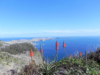
Fuerteventura Super-Durable Map is here!
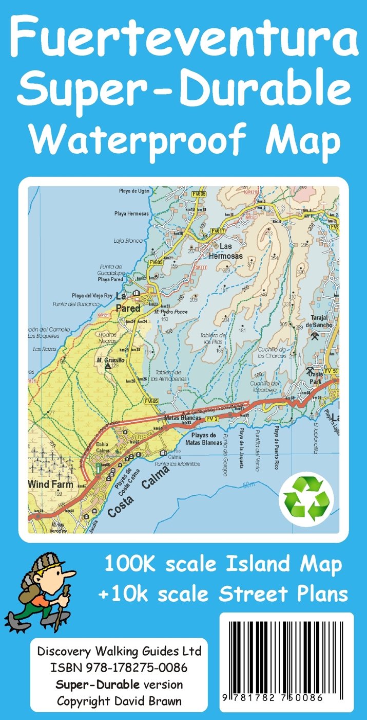
Fuerteventura Super-Durable Map 2015
Just arrived – Fuerteventura Super-Durable Map. HIghly detailed and right up-to-date and printed on a special polymer withstanding rain, wind and folding many times. The island appeals to windsurfers, cyclists, walkers and adventurers, and has miles and miles of pure, clean beaches too.
It’s an intriguing island with a timeless quality, the raw bones of the island shaped by a volcanic past. Unique – once experienced, never forgotten. Read more here

Aloe Vera thrives in Fuerteventura’s desert conditions.
http://www.dwgwalking.co.uk/fuerteventura.htm

On Fuerteventura’s east coast

Wind and Watersports on Fuerteventura
