
Another Challenge?
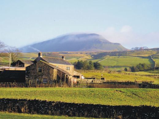
Challenge No.2 The Yorkshire 3 Peaks
Great Britain offers many opportunities for discovering the outdoors, from gentle strolls to big challenges. Here’s one of the big ones. You could plan to tackle the Yorkshire 3 Peaks yourself, or simply lose yourself in the experiences of others who’ve planned and completed the climbs and descents, following them step by step from your own armchair.

Key to success in completing the Challenge Routes in good time is planning, down to the finest details. It’s fascinating to find out how it’s done.

A good large scale map, rip-proof and waterproof is an essential tool. Find out about the most helpful ‘how to’ guide and the best map for the job here.

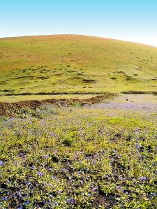
Heading towards Whernside
Pen y Ghent in the early morning

Our last peak – Pen y Ghent crags
Axarquia? Think Costa del Sol
There’s so much more to Spain’s Costa del Sol than sun, sea and sangria. Turn inland and you’re looking at the Axarquia, an unspoiled wildly beautiful and rugged area, waiting for you to explore it. Mountains, wooded hills and plunging gorges, dotted with small towns, tiny settlements and farmsteads give a sense of the true heart of this unique region.


Almond, olive, lemon and orange groves thrive in valleys fed by springs and from streams descending from the mountains, fertile land carved into terraces to maximise the best agricultural areas.
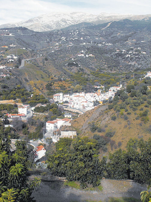
The best way to explore is on foot or by mountain bike. Let’s get started with this free sample circular walk, quite short and not too energetic.


Find out lots more from Discovery Walking Guides HERE.
You’ll also find information about using your device for accessing walks in the Axarquia as well as how to get your hands on the area’s most detailed guidebook and map. There’s also another free walk (pdf format) for you to download.
Lanzarote – what an experience!

Walking in the Haria region of Lanzarote
Each of the Canary Islands has its own unique personality. Lanzarote is strangely surreal. There’s plenty of wide open unspoiled places ideal for exploring by car, bike or on foot.

Lanzarote coastal adventure
Before you visit, get a really good map – and perhaps a walking guidebook.
The best map by a long way is Lanzarote Tour & Trail Super-Durable Map.
But don’t take our word for it – there are dozens of user reviews on line. Here’s a few of them:

Lanzarote Toast Rack Thingy
Kung Fu Panda
5.0 out of 5 stars Highly recommended if planning a driving holiday on Lanzarote
Compared to many “travel” maps this map is very good with an impressive level of detail, including different road types, paths and tracks, contouring, etc. The map itself is printed on a very durable (and ultimately recyclable) plastic sheet material. I would highly recommend this to anyone planning to drive around Lanzarote and perhaps to combine that with some walking. I have just driven around 500 miles during a 10-day holiday and found this invaluable.
Amazon Customer
5.0 out of 5 stars Great product.
I’m a regular user of OS maps & wanted a map of Lanzarote for our forthcoming holiday. This map, with the accompanying book, looks just the job. I particularly like the way the map & book cross-reference each other & the useful information about the walks.
Dylan
5.0 out of 5 stars great product
Fantastic map at a very reasonable price. Large scale shows walking trails etc. Great for research prior to our planned trip.
Freddie
5.0 out of 5 stars Excellent
Excellent map, a must for driving around as road signs are atrocious on Lanzarote for independent motorist! Very good for walks too. Also, yes bended, folded, chucked on back seat & footwell several times, and not a single tear of hole on the folds. Would recommend & will buy for other Canaries when we visit them.
Lanzarote for sunshine, blue seas, amazing huge skies and volcanic sci-fi landscapes. See it for yourself. You’ll never forget it.

Los Cocoteros, Costa Teguise
Walking on La Gomera, Canary Islands – a User Review
Thanks go to David L, just back from walking (and golfing) on the Canary Island of La Gomera. He’s been there before and knows the walking pretty well, and has sent us a detailed review of some of the walks he did (self-adapted in part) using Walk! La Gomera guidebook and La Gomera Tour & Trail map along with digital mapping which he accessed on his smart phone.
Here’s part of David’s walking report:
On 18 December 2017 at 20:24 David L wrote:
“Where? La Gomera – Jardin Tecina Hotel
Walks 2017.11-12.
We did three – or perhaps more accurately, 2.5. We took golf clubs and tennis rackets, too – and my wife is not a bad walker, but not as keen as I am.
We were looking for walks with the least amount of travelling possible, avoiding those with vertigo warnings, and ideally, in the sun.
The walks we did were:
- Playa Santiago to Targa With Variation (Walk 10)
- Degollada de Peraza to San Sebastian (Walk 1)
- Playa Santiago – Baja de Guane – El Aguila – La Trinchera – Playa Santiago (Short Walk)
- Navigational Aids
All walks were undertaken with benefit of the digital version of the Tour & Trail Map on iphone via Memory Map, and hard copy print of the relevant area – one side with route marked – the other unmarked. Full hard copy Tour & Trail Map and Walk! La Gomera Book taken but not referred to en route.
- Weather
Previous visits/walks have been in February and December. In comparison, the countryside was far more burnt up on this occasion, with virtually no greenery, and noticeably warmer than Christmas, but cooler than Feb. We have had NE Alisio weather patterns on previous visits, but, on this occasion, the wind was between south and west.
- Walks
4.1 Playa Santiago To Targa With Variation (Walk 10)

Looking down to Playa Santiago
I had done this walk twice previously, so knew roughly what was involved. The part through the former cultivation terraces is probably fair enough for one experience but, in my view, not more.
So we headed up your down route, which was hot work in mid 20s C, but OK.
The route to the climb up the Playa Santiago cliff is completely different to the map – but more similar to the blow up on the reverse.
Had lunch in the shade close to the FRANCISCO DIAZ BARROSO NAMEPLATE Waypoint. Waypoint beyond this particularly useful as otherwise not clear when to head up the hill to the right – though clearer looking back on it.
Turned left to Targa itself and then along a couple of paths to Alajero. Bar where second path joins road up from Playa Santiago closed. Turned off into central Alajero, where found an open bar with Bus Stop opposite. Perfect! Bus turned up on time and dropped us off by Jardin Tecina for next to nothing.
Conclusion on 1. I think the route we did is better than the one in the book – but I was looking for something different to the route through the cultivation terraces. Probably worth including as an alternative. The variation at the top was not planned in advance, but evolved when we got there.
The leg adjacent to the stream south of Targa is tricky/ steep sided in places with few foot/handholds.
An unexpected hazard was the local authority painting some of the bus stop benches – but not warning of this! My wife wrote off a pair of trousers! Not sure whether this is a seasonal event!
Overall, an enjoyable and rewarding walk. Nice to get up into the cool – and amongst some genuine village life.
4.2 Degollada de Peraza to San Sebastian (Walk 1)

San Sebastian port, La Gomera
This is one of the more accessible walks from Jardin Tecina without vertigo risk- although, by analysis of non-vertigo walks, I have since found a more accessible one, at least to start.
We had toyed with which is gazetted as a’ vertigo trial’ but I had done the bottom 75% of this on my own on a previous visit, and had backed off when I reached a very sheer slope; furthermore, a section of this looked very sheer on Google Earth. It also looked pretty aggressive from the top of Degollada de Peraza.
Up here, we were in cloudy conditions, but the cloud base was well above us.
Shortly after the start, there was no observable issue with the landslide you mention. The path is quite steep sided in places and flat sided in others. Throughout the first 75 % or so, it is dominated by views of the main road from San Sebastian up to Degollada – and traffic noise from it, which was a pity.
On the plus side, we had some good views, and encountered a watchful raven, which I had not previously seen on the island.
The run down into San Sebastian was hard work, along a made up but very uneven ‘donkey’ track.
To return, we had the options of buses or the Fred. Olsen Ferry. We chose the latter, to give us a chance to relax a bit, an opportunity to see this section of coast, and avoid the lengthy/somewhat tedious road route.
We enjoyed the ferry ride, albeit that it was late starting by half an hour, it appeared because of a mechanical issue.
Conclusion on 2. We enjoyed the walk, but were disappointed by the main road/traffic noise impact and the extent of uneven donkey tracks on the descent. Probably good for anyone to do once, but I do not think we would do it again.
4.3 Playa Santiago – Baja de Guane – El Aguila – La Trinchera – Playa Santiago (Short Walk)
This was really a ‘fill in’ while my wife wanted to sunbathe – which I cannot do. I have a friend who has a holiday Property Bond Investment and had stayed at ‘Balcon de Santa Anna’ – and wanted to have a look at this – and the walk round the cliffs outside shown on the map looked interesting.
All went according to plan – having your map on my iphone proved ever useful, as I was not sure how long I was along the walk, on several occasions. Good views of the cliffs and breaking seas – and a pleasantly made up path. Also a short link at the end down to Playa Santiago.
Conclusion on 3. An enjoyable and worthwhile short walk which it might be worth mentioning.
- Overall Conclusion On Walks
We expanded our horizons – though did not visit the Valle Gran Rey/El Cercado area this time.
We enjoyed our walks – which were much aided by your materials and, particularly, the digital functions, which had either not been available or we hadn’t been aware of before. The map on the iphone with the flashing curser and marked waypoints really is a massive help.
We were surprised how warm the weather was – particularly having experienced quite a cool Christmas here once. The countryside was much the most frazzled we had ever seen it.
I am quite a keen bird watcher. I missed the plain swifts over the mountains and villages, normally in abundance. On checking, I see they return to Africa for November and most of December. On the plus side, we had a hoopoe in the hotel grounds, where there were singing chiffchaff and blackcap, and the aforementioned raven.
I attach copies of our tracks, in case of interest. As your book suggests, we took a good bit longer than you did! I also include some vehicle/ferry tracks and one round of the golf course, in case of interest. The speed the ferries travel at is notable – and the time saving from San Sebastian to Playa Santiago by sea, as opposed to land. The golf round was quicker than for an average UK course – because the hole sequence was downhill?”
-0-
Thanks David! User feedback is like gold!
La Gomera – New Ferry Services Make Adventuring Easier

Simplified map of La Gomera by kind permission of David Brawn
La Gomera is a remarkable, almost circular island, a hop away from Tenerife, (Canary Islands) which rises like a giant cake to central forest-cloaked rugged heights, cut by barrancos (ravines) running to the sea. The island is still largely unspoiled which makes it a wonderful destination for hikers and bikers, though getting around takes time as there are few roads. If you don’t wish to get too energetic, simply amble about, dropping into cafés and fish restaurants and breathing in the pure air and beautiful views, enjoying the contrast between this quiet island and its busier big sister Tenerife.
This makes the introduction of not just one but two new sets of ferry services opening up some of the island’s best coastal towns really interesting. You could, for example, take the new car ferry Volcán de Teno from Tenerife’s Los Cristianos at 08.45 and be in Valle Gray Rey 90 minutes later, making a day out in this wonderful ‘Great King’s Valley’ feasible, heading back to Tenerife on the 16.30.
For all the details and to make a booking, see Naviera Armas website.
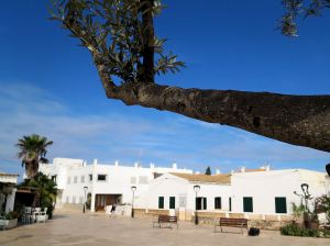
San Sebastian, La Gomera
It’s around five years since three of La Gomera’s most interesting and important coastal towns were linked by ferry services.
Now Fred Olsen has begun 3 services per day (becoming known as the ‘interior ferry line’), linking San Sebastián, Playa de Santiago and Valle Gran Rey, aboard the Benchi Express. If you’re starting from Tenerife you can do the first ferry hop from Los Cristianos. The Benchi can take bicycles, light motorbikes and pets! It also has a small cafeteria and is wheelchair accessible.
For details of the Fred Olsen services, look HERE.

La Gomera – in the south -Tenerife’s Teide visible
Valle Gran Rey
If you’re starting from Tenerife you can do the first ferry hop from Los Cristianos. The Benchi can take bicycles, light motorbikes and pets! It also has a small cafeteria and is wheelchair accessible. Take a look at their website for all the details and to book.
There’s a well- informed and highly readable blog with more La Gomera travel information here.
MAPS AND WALKING GUIDE BOOKS FOR LA GOMERA
For information about large-scale maps, digital mapping information and walking guidebooks, take a look HERE.
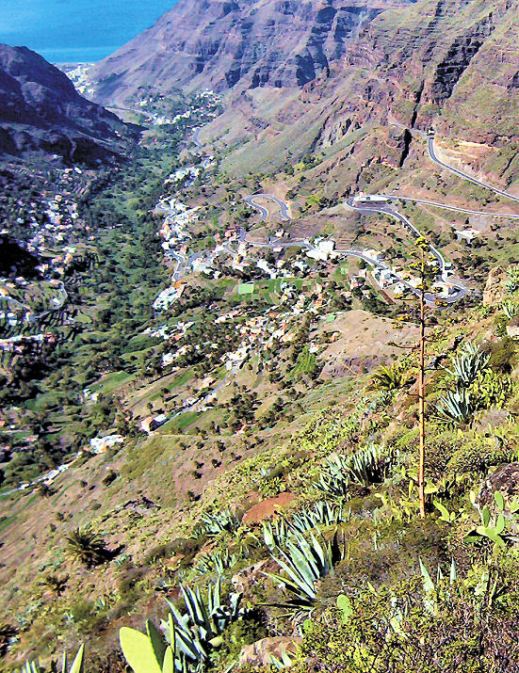
Mallorca; sun, sea, mountains – and Bird Watching too

On Mallorca’s north-west coast
Say ‘Mallorca’ and most people think, “Sun, beaches, mountains, walks, sea-food, sangria …..

Avocet
There’s another excellent reason for visiting this beautiful Balearic island, set in the blue Mediterranean.
Mallorca is home to a surprising number of bird species and acts as a passing-through stop-off for even more bird groups.
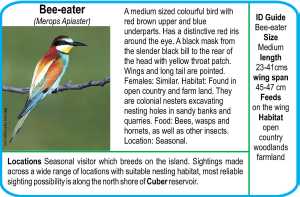
Bee-eater
The island’s varied geography, from coastal cliffs to rugged mountains, from wetlands, reservoirs and coastal areas, offer bird life of many kinds a welcoming place to live, rest, feed and breed.
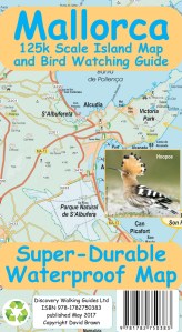
It’s an excellent and up-to-date detailed map (waterproof, tear resistant and guaranteed) perfect for touring the island, with a wealth of details such as best beaches, picnic areas, miradors – plus the locations of the best bird-spotting places.
The map reverse details 51 bird species together with photos and ID information.
Who got a Garmin for Christmas?
If you are one of the many who found a Garmin GPS in their Christmas stocking, this post is for you.
Get your hands on a free sample ‘real-time’ map and see your Garmin come to life. You can choose a sample map of Graciosa ( off Lanzarote, Canary Islands) or Sierra de Aracena (Andalucia, Spain).
What you’ll get is a highly detailed real-time Tour & Trail digital download map, which you can save on your hard drive, transfer to your Garmin GPS CustomMap memory or onto a micro-SD card; you can also use the maps in Garmin Basecamp and Google Earth.
CANARY ISLANDS
Sample segment, Gran Canaria.
Gran Canaria
Tenerife
La Palma
La Gomera
Lanzarote
Fuerteventura
MAINLAND SPAIN
Alpujarras (Sierra Nevada, Andalucia, southern Spain)
Costa Blanca Mountains (Alicante, southern Spain)
Axarquia (Andalucia, southern Spain)
Sierra de Aracena (Helva province, southern Spain)
BALEARIC ISLANDS
Mallorca
Menorca
Formentera
Ibiza
PORTUGUESE ISLANDS
Madeira
For more information about Tour & Trail Maps take a look HERE.
Lanzarote; rains bring the desert to colourful life!

Barranco del Malpaso, Lanzarote
Residents on the Island of Lanzarote tell us that more visitors than usual have been enjoying the great outdoors on this unique island during November and December this year. The dramatic volcanic landscape is unforgettable, though is usually desert-dry with little natural green to see.
It doesn’t rain much (or often) on this arid Canary Island, so recent falls have been most welcome, bringing colour and plant life back to otherwise arid areas.
Helechos, Lanzarote
What a great time to visit! Warm days and sunshine (average of six hours per day in December, even more in January), plus the chance to see the colourful green swathes and flower carpets that happen for only a few weeks each year. Walk, hire a bike or car, or jump on a bus.

La Geria, Lanzarote
There’s plenty of interesting information about the island on the Lanzarote Information website; use the link below.
Take a look at the really useful Lanzarote Information website.
For more on this fascinating and often surprising island, including printed and digital mapping and walking information, take a look here:-

Montaňa Corona, Lanzarote
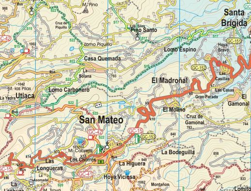
Gran Canaria, Canary Islands – New 3rd Edition Tour & Trail Map
It may not be as well-known as some of the other Canary Islands – that means there’s plenty of room for you to explore this bold, beautiful and dramatic island.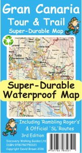
You want mountains and ravines? You want remote, unspoiled sleepy villages? You want abundant verdant woodlands, paths and tracks? You want endemic plant life found nowhere else? You’ve got them all on the island of Gran Canaria.

Map section, Gran Canaria
This third edition includes new walking routes, even clearer ways to show routes and other map features and all the detailed cartographic information that afficionadoes of the Tour & Trail series have come to expect and rely upon. Take a look at this small extract (left).
Detailed updating and addition of new walking routes and additional data have been researched by our ‘on the ground’ walking expert, ‘Rambling Roger‘ and his fellow walking researchers who know the island like the backs of their hands.
If you’re looking for an adventure away from the European winter, with almost guaranteed good weather and great walking (definitely guaranteed) then take a look at Gran Canaria.
(Custom Map digital edition for Garmin Users is available from Discovery Walking Guides’ website. Digital editions are available for 3G/4G GPS apps from Viewranger and My Trails.
Formentera? Where’s that? UPDATE
You’d be forgiven for not knowing the location of this little gem of an island. It’s surprisingly easy to reach and has a delightful personality all its own.
Formentera is one of the Balearic Islands to the east of mainland Spain, in the Meditteranean. It’s the little sister island to Ibiza and is only a 30-minute ferry trip away.
Here’s a few facts and figures:
- Beaches, beaches – so many of them for such a small island and white, clean and beautiful.
- The island had been occupied by the Carthaginians, then the ancient Romans, the Visigoths, the Byzantines, the Vandals, and the Arabs.
- Eventually the island added to the Crown of Aragon and later became part of the medieval Kingdom of Majorca.
- The main island of Formentera is 19 kilometres (12 miles) long and is located about 6 kilometres (4 miles) south of Ibiza in the Mediterranean Sea.
San Francesc, Formentera
- The major villages are Sant Francesc Xavier, Sant Ferran de ses Roques, El Pilar de la Mola and La Savina.
- Formentera comprises one municipality, also called Formentera, and has a population of 9,962 (as at 1 January 2010).
- Its land area is 83.24 square kilometres (32.1 sq mi).
- Cars are easily hired in the port and there’s a good choice of conventional or electric vehicles. There are more electric vehicle charging points here than anywhere else in the world, given its land area.
- Mopeds and bicycles are available to hire; the terrain is mostly flat and there are dedicated cycle lanes in some areas.
- The island has four Martello towers.
- Ferries to Formentera from Ibiza operate every half hour in high season.
- A local Ibizan (eivissenc) variant of the Balearic dialect of the Catalan language is spoken in Formentera though English and other European languages are frequently heard too.
Discovery Walking Guides carried out an intensive cartographic survey on Formentera a few weeks back and design of the new Formentera Tour & Trail Super-Durable Map is well under way.
For full details about the new Formen tera map, click here.
KICKSTARTER PROJECT
How would you like to be part of the launch of this exciting new map project? For a modest pledge you can help this project to fly – and receive free maps too.
There’s still time to be a part of this exciting project.
Take a look at DWG’s Kickstarter Project here.
