
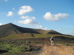
Brecon Beacons – a jewel in Britain’s crown
Today it was announced that the British Government is “looking afresh” at our National Parks which could lead to new additions to the 15 currently designated (the official website is HERE).
In the meantime, I wonder how many of our existing National Parks you’ve visited, and which is your favourite. One of the finest of the existing National Parks (in this author’s opinion) is Brecon Beacons.
Brecon Beacons – on Pen Allt-mawr
Brecon Beacons; Sgwd yr Eira
It’s a beautiful and rewarding place to walk, where high peaks hide glacial lakes in ancient moorland, while man-made reservoirs and canals blend with their natural surroundings, and waterfalls cascade down secret gorges and canals.
Brecon Beacons – Llangattock
Castles, churches and monasteries bear witness to the rich history and heritage that can be experienced while walking in this unique area of natural beauty.
Brecon Beacons – views in all directions
Find out more about the walks in the Brecon Beacons HERE.
Madeira – Garden Isle

Taken by author/researcher Shirley Whitehead – stunning views from Encumeada.
Ah, Madeira! It’s an island that draws visitors back again and again, with its unique plant life, a wide range of wonderful walking from strolls to challenging mountain routes, and a benign climate, making it a year-round destination.
One of the best things about walking here is the sheer variety of routes. If you want gentle, level paths, there are many levada-side routes taking you through lush, natural green scenery. Mountain-lovers have a wealth of inspiring options to choose from. You want views? Wild flowers? Unspoilt villages? Short strolls? Challenging all-day routes? They’re all here.
Madeiran island authorities are well aware of the importance of walking to many of their visitors and do a great job of maintaining routes, keeping them open and safe.

If you’re thinking of a visit to the island, you’ll get much more value from your visit with a good guide book and map in your pocket. Have a look HERE for recommendations.
Where In The World? Pampaneira and Bubión

Bubión village, seen on Walk 3
The Telegraph Travel 15.12.17) wrote an article entitled ‘15 beautiful villages in Spain you’ve probably never heard of‘

Both villages lie in the Poqueira valley, Alpujarras.
We’ve certainly heard of most of them and two in particular took our attention; Pampaneira and Bubión. They are both ‘white villages’ in Spain’s Alpujarras, east of Granada.
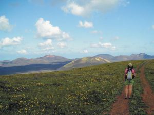
 What a place to walk! Spring is a great time to visit. There’s likely to be snow on the mighty peaks to the north, while Spring flowers burst through on the lower slopes and in the valleys.

Section from ‘Alpujarras Tour & Trail Map’
There’s more Alpujarras walking, mapping and digital information here.
Walking on La Gomera, Canary Islands – a User Review
Thanks go to David L, just back from walking (and golfing) on the Canary Island of La Gomera. He’s been there before and knows the walking pretty well, and has sent us a detailed review of some of the walks he did (self-adapted in part) using Walk! La Gomera guidebook and La Gomera Tour & Trail map along with digital mapping which he accessed on his smart phone.
Here’s part of David’s walking report:
On 18 December 2017 at 20:24 David L wrote:
“Where? La Gomera – Jardin Tecina Hotel
Walks 2017.11-12.
We did three – or perhaps more accurately, 2.5. We took golf clubs and tennis rackets, too – and my wife is not a bad walker, but not as keen as I am.
We were looking for walks with the least amount of travelling possible, avoiding those with vertigo warnings, and ideally, in the sun.
The walks we did were:
- Playa Santiago to Targa With Variation (Walk 10)
- Degollada de Peraza to San Sebastian (Walk 1)
- Playa Santiago – Baja de Guane – El Aguila – La Trinchera – Playa Santiago (Short Walk)
- Navigational Aids
All walks were undertaken with benefit of the digital version of the Tour & Trail Map on iphone via Memory Map, and hard copy print of the relevant area – one side with route marked – the other unmarked. Full hard copy Tour & Trail Map and Walk! La Gomera Book taken but not referred to en route.
- Weather
Previous visits/walks have been in February and December. In comparison, the countryside was far more burnt up on this occasion, with virtually no greenery, and noticeably warmer than Christmas, but cooler than Feb. We have had NE Alisio weather patterns on previous visits, but, on this occasion, the wind was between south and west.
- Walks
4.1 Playa Santiago To Targa With Variation (Walk 10)

Looking down to Playa Santiago
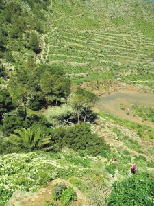
I had done this walk twice previously, so knew roughly what was involved. The part through the former cultivation terraces is probably fair enough for one experience but, in my view, not more.
So we headed up your down route, which was hot work in mid 20s C, but OK.
The route to the climb up the Playa Santiago cliff is completely different to the map – but more similar to the blow up on the reverse.
Had lunch in the shade close to the FRANCISCO DIAZ BARROSO NAMEPLATE Waypoint. Waypoint beyond this particularly useful as otherwise not clear when to head up the hill to the right – though clearer looking back on it.
Turned left to Targa itself and then along a couple of paths to Alajero. Bar where second path joins road up from Playa Santiago closed. Turned off into central Alajero, where found an open bar with Bus Stop opposite. Perfect! Bus turned up on time and dropped us off by Jardin Tecina for next to nothing.
Conclusion on 1. I think the route we did is better than the one in the book – but I was looking for something different to the route through the cultivation terraces. Probably worth including as an alternative. The variation at the top was not planned in advance, but evolved when we got there.
The leg adjacent to the stream south of Targa is tricky/ steep sided in places with few foot/handholds.
An unexpected hazard was the local authority painting some of the bus stop benches – but not warning of this! My wife wrote off a pair of trousers! Not sure whether this is a seasonal event!
Overall, an enjoyable and rewarding walk. Nice to get up into the cool – and amongst some genuine village life.
4.2 Degollada de Peraza to San Sebastian (Walk 1)

San Sebastian port, La Gomera
This is one of the more accessible walks from Jardin Tecina without vertigo risk- although, by analysis of non-vertigo walks, I have since found a more accessible one, at least to start.
We had toyed with which is gazetted as a’ vertigo trial’ but I had done the bottom 75% of this on my own on a previous visit, and had backed off when I reached a very sheer slope; furthermore, a section of this looked very sheer on Google Earth. It also looked pretty aggressive from the top of Degollada de Peraza.
Up here, we were in cloudy conditions, but the cloud base was well above us.
Shortly after the start, there was no observable issue with the landslide you mention. The path is quite steep sided in places and flat sided in others. Throughout the first 75 % or so, it is dominated by views of the main road from San Sebastian up to Degollada – and traffic noise from it, which was a pity.
On the plus side, we had some good views, and encountered a watchful raven, which I had not previously seen on the island.
The run down into San Sebastian was hard work, along a made up but very uneven ‘donkey’ track.
To return, we had the options of buses or the Fred. Olsen Ferry. We chose the latter, to give us a chance to relax a bit, an opportunity to see this section of coast, and avoid the lengthy/somewhat tedious road route.
We enjoyed the ferry ride, albeit that it was late starting by half an hour, it appeared because of a mechanical issue.
Conclusion on 2. We enjoyed the walk, but were disappointed by the main road/traffic noise impact and the extent of uneven donkey tracks on the descent. Probably good for anyone to do once, but I do not think we would do it again.
4.3 Playa Santiago – Baja de Guane – El Aguila – La Trinchera – Playa Santiago (Short Walk)
This was really a ‘fill in’ while my wife wanted to sunbathe – which I cannot do. I have a friend who has a holiday Property Bond Investment and had stayed at ‘Balcon de Santa Anna’ – and wanted to have a look at this – and the walk round the cliffs outside shown on the map looked interesting.
All went according to plan – having your map on my iphone proved ever useful, as I was not sure how long I was along the walk, on several occasions. Good views of the cliffs and breaking seas – and a pleasantly made up path. Also a short link at the end down to Playa Santiago.
Conclusion on 3. An enjoyable and worthwhile short walk which it might be worth mentioning.
- Overall Conclusion On Walks
We expanded our horizons – though did not visit the Valle Gran Rey/El Cercado area this time.
We enjoyed our walks – which were much aided by your materials and, particularly, the digital functions, which had either not been available or we hadn’t been aware of before. The map on the iphone with the flashing curser and marked waypoints really is a massive help.
We were surprised how warm the weather was – particularly having experienced quite a cool Christmas here once. The countryside was much the most frazzled we had ever seen it.
I am quite a keen bird watcher. I missed the plain swifts over the mountains and villages, normally in abundance. On checking, I see they return to Africa for November and most of December. On the plus side, we had a hoopoe in the hotel grounds, where there were singing chiffchaff and blackcap, and the aforementioned raven.
I attach copies of our tracks, in case of interest. As your book suggests, we took a good bit longer than you did! I also include some vehicle/ferry tracks and one round of the golf course, in case of interest. The speed the ferries travel at is notable – and the time saving from San Sebastian to Playa Santiago by sea, as opposed to land. The golf round was quicker than for an average UK course – because the hole sequence was downhill?”
-0-
Thanks David! User feedback is like gold!
La Gomera – New Ferry Services Make Adventuring Easier
Simplified map of La Gomera by kind permission of David Brawn
La Gomera is a remarkable, almost circular island, a hop away from Tenerife, (Canary Islands) which rises like a giant cake to central forest-cloaked rugged heights, cut by barrancos (ravines) running to the sea. The island is still largely unspoiled which makes it a wonderful destination for hikers and bikers, though getting around takes time as there are few roads. If you don’t wish to get too energetic, simply amble about, dropping into cafés and fish restaurants and breathing in the pure air and beautiful views, enjoying the contrast between this quiet island and its busier big sister Tenerife.
This makes the introduction of not just one but two new sets of ferry services opening up some of the island’s best coastal towns really interesting. You could, for example, take the new car ferry Volcán de Teno from Tenerife’s Los Cristianos at 08.45 and be in Valle Gray Rey 90 minutes later, making a day out in this wonderful ‘Great King’s Valley’ feasible, heading back to Tenerife on the 16.30.
For all the details and to make a booking, see Naviera Armas website.

San Sebastian, La Gomera
It’s around five years since three of La Gomera’s most interesting and important coastal towns were linked by ferry services.
Now Fred Olsen has begun 3 services per day (becoming known as the ‘interior ferry line’), linking San Sebastián, Playa de Santiago and Valle Gran Rey, aboard the Benchi Express. If you’re starting from Tenerife you can do the first ferry hop from Los Cristianos. The Benchi can take bicycles, light motorbikes and pets! It also has a small cafeteria and is wheelchair accessible.
For details of the Fred Olsen services, look HERE.

La Gomera – in the south -Tenerife’s Teide visible

Valle Gran Rey
If you’re starting from Tenerife you can do the first ferry hop from Los Cristianos. The Benchi can take bicycles, light motorbikes and pets! It also has a small cafeteria and is wheelchair accessible. Take a look at their website for all the details and to book.
There’s a well- informed and highly readable blog with more La Gomera travel information here.
MAPS AND WALKING GUIDE BOOKS FOR LA GOMERA
For information about large-scale maps, digital mapping information and walking guidebooks, take a look HERE.
Brittany’s North – Wonderful Walking

Rollercoaster walking on Walk 10, Plougasnou
How do you like the sound of walking through bucolic countryside, or discovering an orchid-lined pilgrim’s way?
What about exploring a fairy-tale trail winding through ancient woodland, or strolling alongside an idyllic trout stream?
You could be scrambling across a cataract of rocks or following the airy contours of the spectacular coastal path, weaving between delicately sculpted dunes or wandering across the flat sands of the tideland.

Port de Ploumanach on Walk 19, Ploumanac’h
Gaze at the wide blue horizon from a wind battered headland or simply lounge about on a breathtakingly beautiful beach.
Brittany, (north-western France) is a perfect ‘get away from it all’ experience.

Abbaye du Tronchet cloisters, Walk 37

Rolling pastures on Walk 32, Langast
Boasting more than 3,000 kilometres of waymarked paths, a tourist infrastructure that is highly developed without being obtrusive, and regular budget flights, the region has all you need for a long-weekend away or a full walking holiday.
If walking in Brittany has you intrigued, we recommend you take a look at experienced walker/researcher/author Charles Davis’ guidebook, Walk! Brittany North.
There’s more information on Discovery Walking Guides’ pages also.
Maps for Corfu, Mallorca and Costa del Sol (Axarquia)

Costa del Sol (La Axarquia)
Are you off to any of these destinations soon?
Or maybe you’re thinking of planning a trip for later in the year, when the summer heat subsides and most visitors disappear, leaving all that space (almost) all yours.

Corfu Tour & Trail Map section
If so, then here’s a great opportunity to get hold of digital Custom Maps free to download.
If you’ve ever used (or seen) one of DWG’s Tour & Trail maps you already know how detailed, clear and up to date they are.

On Mallorca’s north-west coast
Take a look at Discovery Walking Guides’ latest ENews to get hold of yours!
Who got a Garmin for Christmas?
If you are one of the many who found a Garmin GPS in their Christmas stocking, this post is for you.
Get your hands on a free sample ‘real-time’ map and see your Garmin come to life. You can choose a sample map of Graciosa ( off Lanzarote, Canary Islands) or Sierra de Aracena (Andalucia, Spain).
What you’ll get is a highly detailed real-time Tour & Trail digital download map, which you can save on your hard drive, transfer to your Garmin GPS CustomMap memory or onto a micro-SD card; you can also use the maps in Garmin Basecamp and Google Earth.
CANARY ISLANDS
Sample segment, Gran Canaria.
Gran Canaria
Tenerife
La Palma
La Gomera
Lanzarote
Fuerteventura
MAINLAND SPAIN
Alpujarras (Sierra Nevada, Andalucia, southern Spain)
Costa Blanca Mountains (Alicante, southern Spain)
Axarquia (Andalucia, southern Spain)
Sierra de Aracena (Helva province, southern Spain)
BALEARIC ISLANDS
Mallorca
Menorca
Formentera
Ibiza
PORTUGUESE ISLANDS
Madeira
For more information about Tour & Trail Maps take a look HERE.
Lanzarote; rains bring the desert to colourful life!
Barranco del Malpaso, Lanzarote
Residents on the Island of Lanzarote tell us that more visitors than usual have been enjoying the great outdoors on this unique island during November and December this year. The dramatic volcanic landscape is unforgettable, though is usually desert-dry with little natural green to see.
It doesn’t rain much (or often) on this arid Canary Island, so recent falls have been most welcome, bringing colour and plant life back to otherwise arid areas.

Helechos, Lanzarote
What a great time to visit! Warm days and sunshine (average of six hours per day in December, even more in January), plus the chance to see the colourful green swathes and flower carpets that happen for only a few weeks each year. Walk, hire a bike or car, or jump on a bus.
La Geria, Lanzarote
There’s plenty of interesting information about the island on the Lanzarote Information website; use the link below.
Take a look at the really useful Lanzarote Information website.
For more on this fascinating and often surprising island, including printed and digital mapping and walking information, take a look here:-
Montaňa Corona, Lanzarote
Choosing A Winter Walking Destination
What do you need for an enjoyable walking holiday when winter closes in on the northern hemisphere?
RELIABLE WARMTH AND SUNSHINE

On La Gomera – Tenerife’s Teide visible
A 5 hour flight south (from the UK) gets you to the Canary Islands, off the coast of Africa. You can expect about six hours of sunshine per day (average) with highs of 20C in December though of course there are variations depending on the island and location.

Levada Nova, Madeira
Madeira is a bit closer and almost as sunny (around 5 hours) and almost as warm though the chance or rain is higher. That’s why Madeira is so green and floriferous!
A GOOD CHOICE OF HOTELS, NIGHT LIFE, SHOPS and RESTAURANTS
The Canary Islands and Madeira don’t really have a ‘closed’ season for tourism so you will find a wide range of accommodation, eating places, shops and night life. There are quieter, smaller places to stay if you want to get away from the ‘bright lights’.
EASY TO GET TO
There are plenty of flights all year round to the Canaries and to Madeira.
WHAT’S THE WALKING LIKE?
Each of the Canaries is unique, offering a wide choice of walks and challenging hikes. If you are looking for a pleasant stroll for an hour or two, a coastal discovery route or a full day in the mountains (or something inbetween), the Canaries are an ideal choice.
Madeira is rugged and steep, though the many levada walks (mostly level walks alongside narrow water canals) make it a walking destination with plenty of choice for all.
FIND OUT MORE ABOUT CANARY ISLANDS WALKING HERE:-
FOR MORE ABOUT WALKING ON THE GARDEN ISLE OF MADEIRA, LOOK HERE:-
Madeira
