
Beautiful Madeira – Walking Route Updates (Oh, and Porto Santo)
Madeira – a firm favourite

Stunning views to Encumeada, Madeira (copyright author/researcher Shirley Whitehead)
Madeira is beautifully green and floriferous but sometimes the necessary abundant rainfall (or in high summer, forest fires) lead to temporary walking route closures. Thankfully, the island authorities are quick to pinpoint problem sections and repair them. In any case, there are so many great walks that you’ll always find plenty to choose from anytime that you visit.
Have a look HERE for walking information and suggested walking guidebooks and detailed walking maps.

Approaching Ribeira Fundo, Madeira (copyright author/researcher Shirley Whitehead)
At the time of writing, the official PR walking routes currently affected by temporary closures are:
PR12 – Caminho Real da Encumeada
PR14 – Levada dos Cedros
PR16 – Levada Fajã do Rodrigues
PR17 – Caminho do Pináculo e Folhadal
PR19 – Caminho Real do Paul do Mar
Go to the official pages for up-to-date information regarding route closures.
-0-

Descent to the land Bridge, São Lourenço Madeira (copyright author/researcher Shirley Whitehead).
Going to Madeira? Hop to Porto Santo
If you’re going to Madeira, why not take a day or two take a look at little sister island Porto Santo?
Walkers can try the two official PR walking routes, PS PR1 – Vereda do Pico Branco e Terra Chã and the PS PR2 – Vereda do Pico Castelo
For the official Porto Santo tourist information including walking look HERE.
The ferry from Funchal, Madeira to Porto Santo takes about 2 hours 15 minutes. Please check the freey information website for departure times and note that in early January each year ferries are often out of service for regular maintenance. Ferry information HERE.
-0-
Porto Santo Nature Trail Event 03/04 March 2018
This event is the 5th stage of the “Circuit Trail Madeira 2017/2018”. As you can see, the adult routes look pretty challenging – though you do have until March 2018 to get into shape!
- Porto Santo Nature Trail (PSNT) – 42.3 km and 1926m climb (circular format);
- Trail do Porto Santo (TPS) – 21.9 km and 107m climb (linear format);
- Mini Trail do Porto Santo (MTPS) – 8.9 km and 395m climb (linear format);
There’s also a children’s event:
Kids Trail do Porto Santo (KTPS) between 1 km and 3 km (linear format).
For all the information, look HERE.
-0-
You might also find this post useful for getting out and about on Madeira.
La Gomera – New Ferry Services Make Adventuring Easier
Simplified map of La Gomera by kind permission of David Brawn
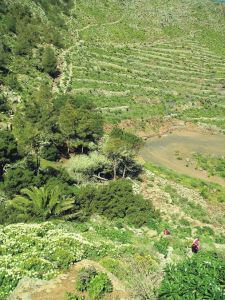
La Gomera is a remarkable, almost circular island, a hop away from Tenerife, (Canary Islands) which rises like a giant cake to central forest-cloaked rugged heights, cut by barrancos (ravines) running to the sea. The island is still largely unspoiled which makes it a wonderful destination for hikers and bikers, though getting around takes time as there are few roads. If you don’t wish to get too energetic, simply amble about, dropping into cafés and fish restaurants and breathing in the pure air and beautiful views, enjoying the contrast between this quiet island and its busier big sister Tenerife.
This makes the introduction of not just one but two new sets of ferry services opening up some of the island’s best coastal towns really interesting. You could, for example, take the new car ferry Volcán de Teno from Tenerife’s Los Cristianos at 08.45 and be in Valle Gray Rey 90 minutes later, making a day out in this wonderful ‘Great King’s Valley’ feasible, heading back to Tenerife on the 16.30.
For all the details and to make a booking, see Naviera Armas website.

San Sebastian, La Gomera
It’s around five years since three of La Gomera’s most interesting and important coastal towns were linked by ferry services.
Now Fred Olsen has begun 3 services per day (becoming known as the ‘interior ferry line’), linking San Sebastián, Playa de Santiago and Valle Gran Rey, aboard the Benchi Express. If you’re starting from Tenerife you can do the first ferry hop from Los Cristianos. The Benchi can take bicycles, light motorbikes and pets! It also has a small cafeteria and is wheelchair accessible.
For details of the Fred Olsen services, look HERE.

La Gomera – in the south -Tenerife’s Teide visible

Valle Gran Rey
If you’re starting from Tenerife you can do the first ferry hop from Los Cristianos. The Benchi can take bicycles, light motorbikes and pets! It also has a small cafeteria and is wheelchair accessible. Take a look at their website for all the details and to book.
There’s a well- informed and highly readable blog with more La Gomera travel information here.
MAPS AND WALKING GUIDE BOOKS FOR LA GOMERA
For information about large-scale maps, digital mapping information and walking guidebooks, take a look HERE.
Mallorca; sun, sea, mountains – and Bird Watching too

On Mallorca’s north-west coast
Say ‘Mallorca’ and most people think, “Sun, beaches, mountains, walks, sea-food, sangria …..

Avocet
There’s another excellent reason for visiting this beautiful Balearic island, set in the blue Mediterranean.
Mallorca is home to a surprising number of bird species and acts as a passing-through stop-off for even more bird groups.

Bee-eater
The island’s varied geography, from coastal cliffs to rugged mountains, from wetlands, reservoirs and coastal areas, offer bird life of many kinds a welcoming place to live, rest, feed and breed.

It’s an excellent and up-to-date detailed map (waterproof, tear resistant and guaranteed) perfect for touring the island, with a wealth of details such as best beaches, picnic areas, miradors – plus the locations of the best bird-spotting places.
The map reverse details 51 bird species together with photos and ID information.
Corfu – One in 6000
With approximately 6000 Greek islands and islets to choose from, why Corfu?

Just one of Corfu’s beautiful bays.
Well, it’s a lush green island with white beaches and azure seas, diverse landscapes and a long history, offering lovers of nature, Greek culture and

Rare Swallowtail, Corfu
water sports alike an unforgettable experience.
The coastline provides many ‘wow’ moments, with plunging cliffs, picture-postcard bays and inlets and impossibly blue seas.

Wild Tortoise, Corfu
Corfu has an enduring relationship with the sea, each sheltered inlet and harbour home to fishing boats or pleasure craft.
You’ll find plenty of choices on offer if you want a trip around Corfu’s dramatic coastline, best viewd from the water.
Of course, there are wonderful seafood restaurants, many modestly priced especially away from the resorts.

Lefkimis Bay, Corfu

The Kaiser’s Throne, Corfu
The mountainous north rolls down towards the south, cypress forests cloaking the hillsides while ancient olive groves and fruit orchards thrive at their feet.
There are walking trails and paths, with the icing on the cake being the Corfu Trail which you can choose to do in part or tackle the whole thing.

The ‘main road’ through Ano Korakiana, Corfu.
There’s a sprinkle of ancient, sleepy villages resonating with the island’s long history. If you’re driving yourself through in a hire car, prepare to breathe in!
Back in June 2016 we posted ‘Corfu – An Island In Need Of A Good Map’. Good news – here it is!
 Just published, this is the perfect map, whatever you plan to do on this lovely Greek island.
Find the best beaches and places of interest. Follow the Corfu Trail in whole or part). IF you plan to drive, this is the most up-to-date map showing all roads and junctions.
Corfu – once visited, never forgotten.
Island Hopping – Twice The Adventure Nº2 – Tenerife to La Gomera
Hop From Tenerife to La Gomera
There’s no doubt that Tenerife is one of the most popular island destinations, easily reached in around 5 hours from much of Europe and enticing with sunny skies, warm temperature, beaches and mountains and (if you want it) plenty of nightlife.
Looking down to San Sebastian (La Gomera), Pico del Teide on Tenerife in the distance
If you fancy a complete contrast, sample a day on the island of La Gomera, so close to Tenerife yet oh! so different – rugged, shaped like a well-risen circular cake topped by ancient laurel forests and with mighty ravines slicing down to the sea.
It’s laid back, offering astounding views and walks, little tipico cafés and restaurants, flamboyant plant life and stunning geology. Oh, and it has beaches.

Valle Gran Rey, La Gomera
Frequent ferries mean you can be there in under an hour from Los Cristianos, Tenerife, landing in Gomera’s capital San Sebastián, where public buses await in the harbour to take you onward. Car hire ofices and taxis are located here too.
Journey time: The fastest crossing from Tenerife to La Gomera goes via the harbours Los Cristianos de Tenerife to San Sebastián de La Gomera. The Benchijigua Express Ferry covers this distance in about 50 minutes. Other (slower) ferry services are offered by Naviera Armas. Pre-booking is essentail.
What to do? In one day, you’ll need to be selective. Take a look at these Trip Advisor suggestions.
For lots more information about La Gomera, including maps, look here.
There’s a brand-new edition of Walk! La Gomera, just published; look here.
Island Hopping – Twice The Adventure
Day Trip – Island Hopping Nº1
Going to Lanzarote? Hop to Fuerteventura!

Aloe Vera thrives in Fuerteventura’s desert conditions.
You’ve planned your trip to Lanzarote, booked flights, accommodation and maybe a hire car.
Why not plan a day trip to the next island south too, just a 25 to 45 minute ferry trip away?
Fuerteventura is Lanzarote’s big sister and has its own personality. Watersports are big here (think Fuerte+Ventura = Strong Wind) and there are biking and hiking routes too. Or hire a car for the day and take a look. At about 100 kilmetres in length, it’s too big to see everything in just one day, though you’ll get a taste of the place and may want to return for a longer visit.

Watersport heaven on Fuerteventura’s east coast
Things to do – Trip Advisor has good suggestions for beaches, cafes, museums and watersports.
It’s useful to get hold of a good map before you go. Take a look at this link for up-to-date map information:
http://www.dwgwalking.co.uk/fuerteventura.htm

Established in 1405, Fuerteventura’s origianl capital of Betancuria is a step back in time.
There’s a useful website for those wanting more information about hiking and biking on Fuerteventura; take a look at:
Are You Off To Walk Madeira? Check Before You Walk.

Aloe aborescens clinging to Madeiran cliffs
Madeira! What a great desination, especially at this time of year.
Swapping the dark and cold of Northern Europe for Madeira’s green and spring-like mountains is a popular choice at this time of year.
If you are planning to walk there, it’s worth checking that the paths you’re planning on following are open. The best place to look for information is on the official ‘Visit Madeira’ tourism website. To see which routes are open or temporarily closed, LOOK HERE.
If you are already on the island, you can also ask in Tourist Offices who usually have up to date information on walks that are open/closed.

A spectaculat waterfall on the Levada da Ribeira da Janela
At the moment only three of the official routes are temporarily closed. The authorities are vigilant and usually restore routes quickly; often, the problem is a landslip after heavy rain.
The three routes to avoid at the time of writing this are:
PR1 – Vereda do Areeiro
Temporarily closed
PR12 – Caminho Real da Encumeada
Temporarily closed
PR19 – Caminho Real do Paul do Mar
Temporarily closed

Levada Nova, Madeira
There’s so much great walking on Madeira that you’ll find plenty to tempt you, from strolls to all-day high altitude challenges. Even if you aren’t keen to do much walking, it’s a great idea to use the local buses which give you brilliant (sometimes a bit hairy!) adventures around the island for pocket-money prices.
There’s a great bus map available, also really useful as a driving map; LOOK HERE for details of the Madeira Bus & Touring Map.
For more information including details our two Madeira Walks guidebooks Madeira Tour & Trail Map and digital mapping for Madeira, take a look at Discovery Walking Guides; Madeira pages.
Lanzarote; rains bring the desert to colourful life!
Barranco del Malpaso, Lanzarote
Residents on the Island of Lanzarote tell us that more visitors than usual have been enjoying the great outdoors on this unique island during November and December this year. The dramatic volcanic landscape is unforgettable, though is usually desert-dry with little natural green to see.
It doesn’t rain much (or often) on this arid Canary Island, so recent falls have been most welcome, bringing colour and plant life back to otherwise arid areas.

Helechos, Lanzarote
What a great time to visit! Warm days and sunshine (average of six hours per day in December, even more in January), plus the chance to see the colourful green swathes and flower carpets that happen for only a few weeks each year. Walk, hire a bike or car, or jump on a bus.
La Geria, Lanzarote
There’s plenty of interesting information about the island on the Lanzarote Information website; use the link below.
Take a look at the really useful Lanzarote Information website.
For more on this fascinating and often surprising island, including printed and digital mapping and walking information, take a look here:-
Montaňa Corona, Lanzarote
Gran Canaria, Canary Islands – New 3rd Edition Tour & Trail Map
It may not be as well-known as some of the other Canary Islands – that means there’s plenty of room for you to explore this bold, beautiful and dramatic island.
You want mountains and ravines? You want remote, unspoiled sleepy villages? You want abundant verdant woodlands, paths and tracks? You want endemic plant life found nowhere else? You’ve got them all on the island of Gran Canaria.
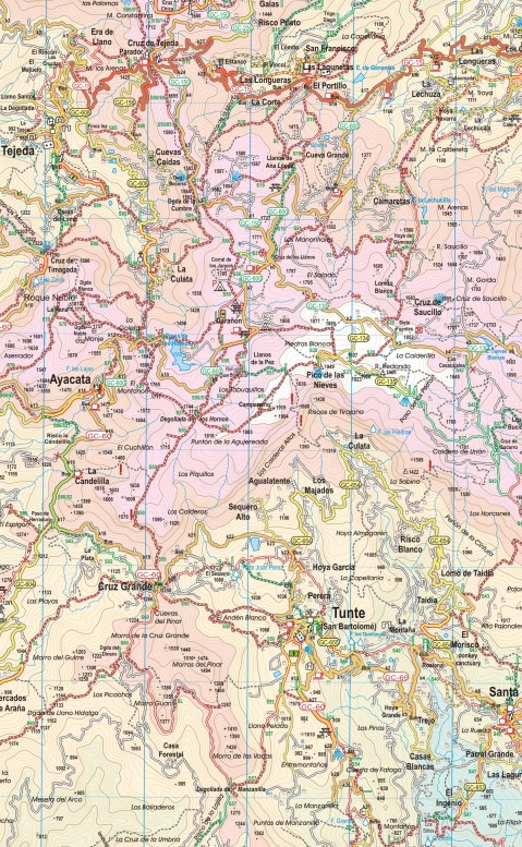
Map section, Gran Canaria
This third edition includes new walking routes, even clearer ways to show routes and other map features and all the detailed cartographic information that afficionadoes of the Tour & Trail series have come to expect and rely upon. Take a look at this small extract (left).
Detailed updating and addition of new walking routes and additional data have been researched by our ‘on the ground’ walking expert, ‘Rambling Roger‘ and his fellow walking researchers who know the island like the backs of their hands.
If you’re looking for an adventure away from the European winter, with almost guaranteed good weather and great walking (definitely guaranteed) then take a look at Gran Canaria.
(Custom Map digital edition for Garmin Users is available from Discovery Walking Guides’ website. Digital editions are available for 3G/4G GPS apps from Viewranger and My Trails.
Corfu – an island in need of a good map

Old Perithia
Discovery Walking Guides cartographic survey team has just returned from Corfu, and boy, does Corfu need a good map.
It’s a tricky island for visitors wanting to travel around by hire car or bike, because road signage is confusing (or non-existent) and unusually, roads have not been allocated road numbers.

Lefkimis Bay, Corfu
A few stretches of tarmac do have kilometre markers though this information is patchy to say the least. We also discovered that car systems such as TomTom and similar don’t work here.

Palaiokastritsa Bay, Corfu
So, it tuned out to be an interesting and most productive visit. The new Corfu Tour & Trail Super-Durable Map design work will shortly be under way, with a scheduled publication date around December 2016.

The Kaiser’s Throne, Corfu
With a good, reliable and newly researched map, visitors can confidently go beyond the usual tourist spots and discover the heart of this beautiful island.
Some ‘main roads’ through Corfu’s mountain villages are a bit of a squeeze!

The ‘main road’ through Ano Korakiana, Corfu.

Rare Swallowtail, Corfu
Corfu’s flora and fauna are beautiful.

Wild Tortoise, Corfu
