
Exmoor – wonderful walking and now OSlike Custom Maps too
Wonderful walking in Britain’s Exmoor!
Here’s just one splendid view overlooking Lynton and Lynmouth while following Walk 16 from ‘Walk! Exmoor’ with David and Carol Hitt. For more information about walks here, see : http://www.dwgwalking.co.uk/exmoor.htm
And now – for Garmin users – download OSlike Custom maps for Exmoor, overlaid with the 40 varied routes from Walk! Exmoor.
OSlike Custom Maps can be used in Google Earth, Garmin Basecamp and Garmin gps units.
There’s east and west sections to download, (£3.99 each) which can be found here: http://www.dwgwalking.co.uk/garminexmoorecustommap.htm
and here: http://www.dwgwalking.co.uk/garminexmoorwcustommap.htm
Walk Spain’s Alpujarras: download the guide

One of the White VIllages
Walk! The Alpujarras is now also available in pdf format.
This beautiful region of southern Spain offers high peaks, long ridges, clear mountain streams, woodland, amazing views and picturesque white villages.
‘Walk! The Alpujarras’ takes you through 34 detailed routes with the expert guidance of author/researcher Charles Davis.
Try a free sample walk here: http://www.dwgwalking.co.uk/178walkalpujarrassample.pdf
To see details of the printed book, the Alpujarras Tour & Trail Map and the book as a pdf, look here: http://www.dwgwalking.co.uk/alp34walks.htm
Mallorca (Balearic Islands) Author Update
 From Charles Davis, author/researcher
20 February 2014 17:39
Bit of vital information for our updates pages:
Anybody planning on walking the Dry Stone Way, Mallorca (GR221) has a slightly surreal and stunningly irritating headache coming their way.
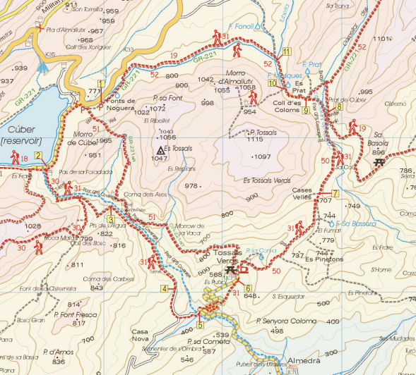
The refuge at Tossals Verds is closed on safety grounds and won’t be open before October if then. There is no comparable accommodation between Soller and Lluc. The ‘alternatives’ (such as they are) proposed by the authorities can be found here:
http://www.conselldemallorca.net/media/34483/alternatives_tossals_ANG.pdf
Taxiing back and forth between Cuber and Lluc rather spoils the point of doing a LDP*. Staying at Cuber would be lovely, though it might be a bit Spartan for some tastes and implies carrying extra weight. To get an idea of what this unmanned refuge is like, see
https://www.youtube.com/watch?v=bwweVJtw1fE or google ‘refugio cuber’ for photos.
*LDP = Long Distance Path
The map section above shows a section of Walk! Mallorca Tour & Trail Map to illustrate the relative locations of Tossals Verd and Cuber. For more information on Mallorca maps and walking see http://www.dwgwalking.co.uk/mall.htm
Get Away From Winter – there’s wall-to wall sunshine now in La Palma
If you’re in the UK or northern Europe you have most likely had enough of gales, floods and dark skies. On the teardrop-shaped volcanic island of La Palma, Canary Islands, the forecast ahead is for almost wall-to-wall sunshine with daily highs of 20-22C and not much less than 16C in the night.
Even better, it offers dramatic and wonderful walking. And you could be there within 5 hours’ flight time from UK and many European airports.
The image (right) was taken while following the Ruta de Los Volcanos.
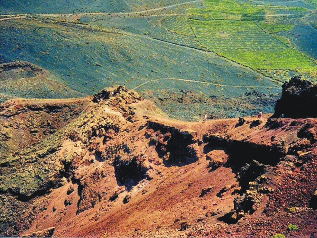
And how about following the route of the southern volcanoes (left)? Much of the walk is along the volcanic ridge that bisects the island west-east, offering super views. Here’s how it looks on the La Palma Tour & Trail Map.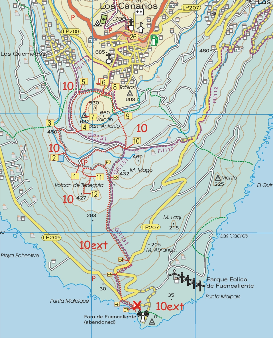
 The image below shows a walker starting out on the Roque Palermo route; La Palma’s famous observatory can be glimpsed in the background.
There’s more information here:- http://www.dwgwalking.co.uk/lap.htm
Field Test Report – Gran Canaria Tour & Trail Map
Our thanks go to Andrew who field tested the beta version of Gran Canaria Tour & Trail Map:-
On 2 February 2014 Andrew K wrote:
Hi both,
Just a quick note to thank you both for giving me access to the beta Tour & Trail map for Gran Canaria.
We didn’t come across any issues whilst using it around the central and southern parts of the island. I used it on my Android smartphone and loaded the gpx track files which matched up perfectly to the map.
Looking forward to purchasing the final version when it’s available.
All the best,
Andrew
More information about this amazing island can be found here;
Gran Canaria Tour & Trail Super-Durable Map – design complete!
We’re excited to anounce that Gran Canaria Tour & Trail Super-Durable Map design is complete and  the print files are now with our specialist map printer. We’ll let you know when they’re ready to buy.
If you’ve never visited – why not? It’s a dramatic, beautiful island and only around 4 hours’ flight time from much of Europe. See more information http://www.dwgwalking.co.uk/gcan.htm
We’ve been working with Rambling Roger, resident on the island, who knows the island’s walking like the back of his hand. More about Roger here http://www.ramblingroger.com/
If you are a Garmin user you don’t even have to wait! Get the downloadable map for Garmin here http://www.dwgwalking.co.uk/garminGranCanaria.htm and you could be on those trails within hours.
Gran Canaria – mapping update
For those itching to get their hands on the first really detailed and up-to-date map for walkers/hikers/bikers on the island of Gran Canaria (Canary Islands, Spain), see this report from the cartographer (27 January 2014):-
David Brawn
“I’ve just today reclassified the roads after chatting with Rambling Roger, and then added the island’s beaches. Just a couple of corrections, add a Lat/Long 1 minute grid, add flower symbols for all the gardens and garden centres, then design a new legend and I think I’m nearly there with the new Gran Canaria Tour & Trail Super-Durable Map.”
David Brawn, Cartographer, DWG Ltd
