
The Garden Isle of Madeira – escape from winter!
Winter has finally arrived in northern Europe and the days are short and dark. It’s the ideal time to enjoy Madeira. Lush vegetation, mountains and levadas await your discovery.

Aloe aborescens

Madeira Tour & Trail Map
Discovery Walking Guides have released their 8th editions of their Tour & Trail Maps to the Garden Isle (a choice of map-paper or Super-Durable polymer). Walkers keep on buying these for their accuracy, clarity and wealth of up-to-date detail.
Ask for them in your favourite bookshop or get them online from your choice of stockists.
Here’s a link to amazon UK’s information page about the Super-Durable edition:

Read Discovery Walking Guides’ latest ENewsletter
Check out Discovery Walking Guides’ latest ENewsletter.
It’s packed with plenty of ideas for escaping winter to wonderful warm walking destinations, plus features on the Isle of Wight and Fuerteventura.
See it all http://ymlp.com/zK1jmu
Isle Of Wight Adventure Package – now released
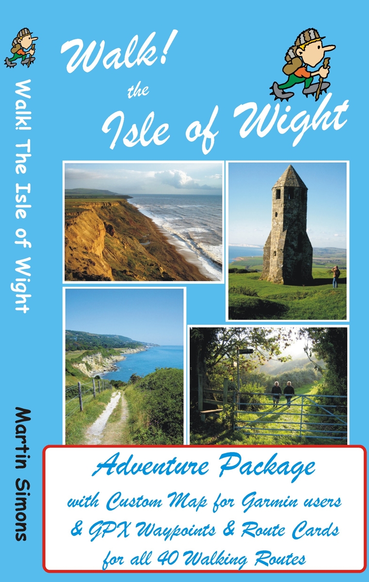
GPS users take note; our latest edition Walk! The Isle of Wight walks have been transformed into pdf route cards and re-packaged with ‘OSlike’ digital mapping for the Isle of Wight and gpx waypoints.
This is a great time to explore the Isle Of Wight; school holidays are almost over and there’s always the chance of some late summer sunshine.
Isle of Wight Adventure Package:-
Isle of Wight ‘OSlike’ Custom Map
gpx waypoints,
pdf ebook of 41 A4 pages
– all delivered as a ZIP file download for £11.99
See all the details here:-
Walk! The Isle Of Wight – new edition is here!
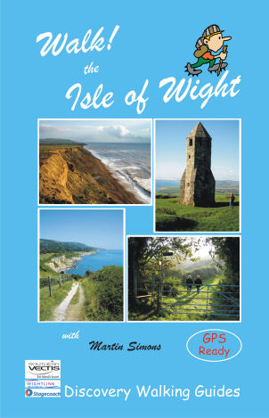 There’s no doubt that the Isle Of Wight is a wonderful place to visit and the best way to experience the island is on foot and by bus.
Walk! The Isle Of Wight (3rd edition) details 40 step-by-step walking routes, most accessed using public bus services.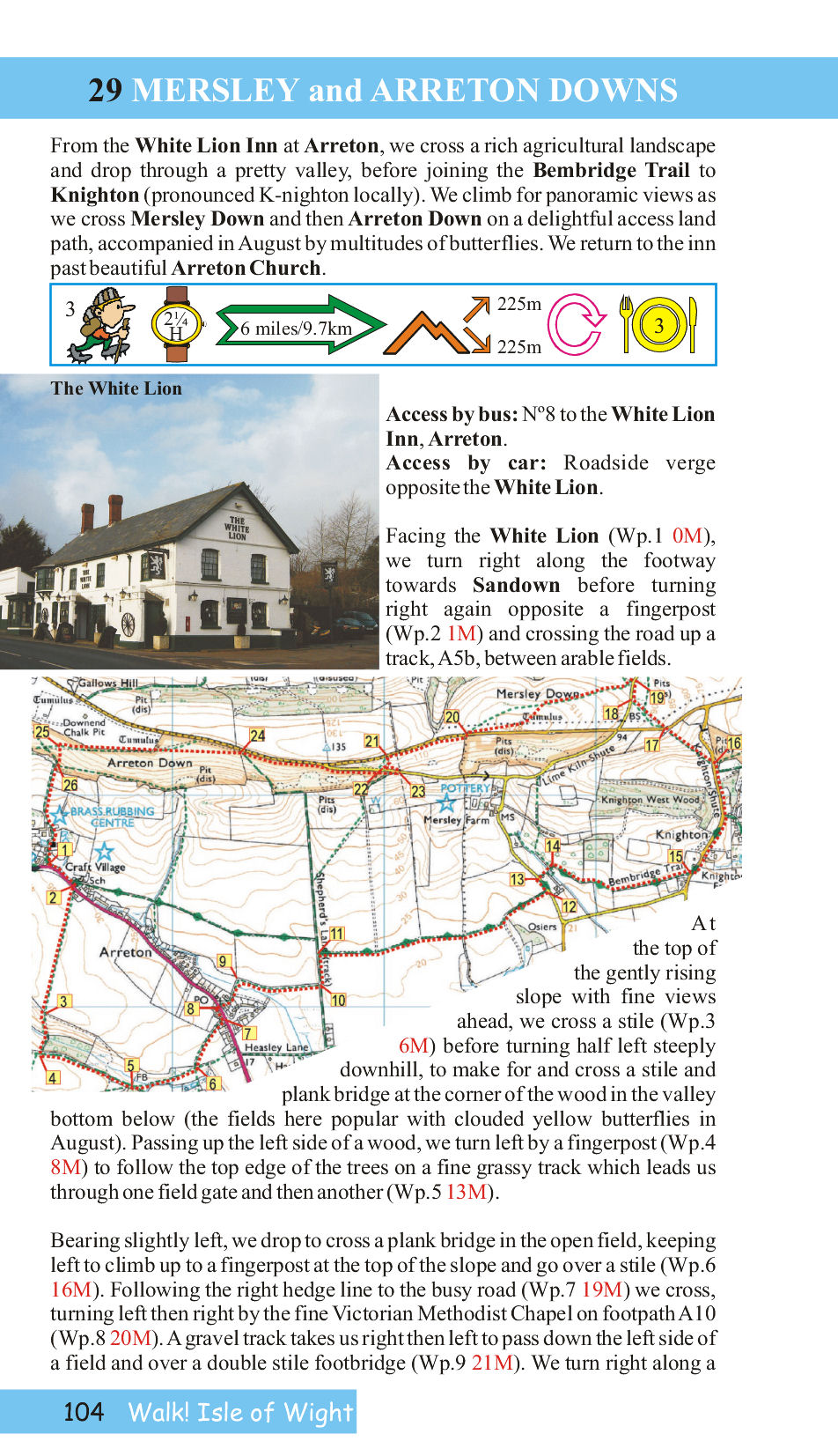
Each walk has its own colour OS Map, with the walking route and waypoints highlighted.
Here’s a sample page from the book so you can see what you’re getting:-
Good pubs (author tested) are recommended at the end of many of the routes.
See all the info here:-
Walk England Coast to Coast – a new approach to a classic adventure
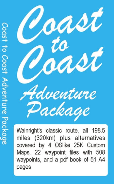 This classic route, pioneered by Alfred Wainwright, crosses northern England from – you guessed it – coast to coast. There are other books available – so what makes this one different?
Here’s what the author and researcher of this new take on a favourite challenge, has to say:-
“On a fortnight’s adventure with my mates Keith and Nigel from St Bees to Robin Hood’s Bay (July 2012) I talked to loads of C2Cers subtly asking what would make the route better. What everyone wanted was accurate navigation along the route, especially if it included ‘real time’ mapping.
There are loads of guide books about the Coast to Coast so rather than adding another book I have produced what every C2Cer wants:-
A system of accurate navigation for the whole route using ‘real time’ mapping on a Garmin gps or Viewranger phone app.
The result is a Stage by Stage guide, with alternatives, that gives you a real time mapping gps unit showing exactly where you are on the route along with the walking instructions that will ensure that you stay on the correct route.
On your Garmin, or Viewranger app, you will be on the right track every step of the way for all of the 198.5 miles (320km) from St Bees until you arrive at The Bay Hotel in Robin Hood’s Bay; where you will find the Wainright Bar with its C2C ‘sign in’ book.” David Brawn, author/researcher
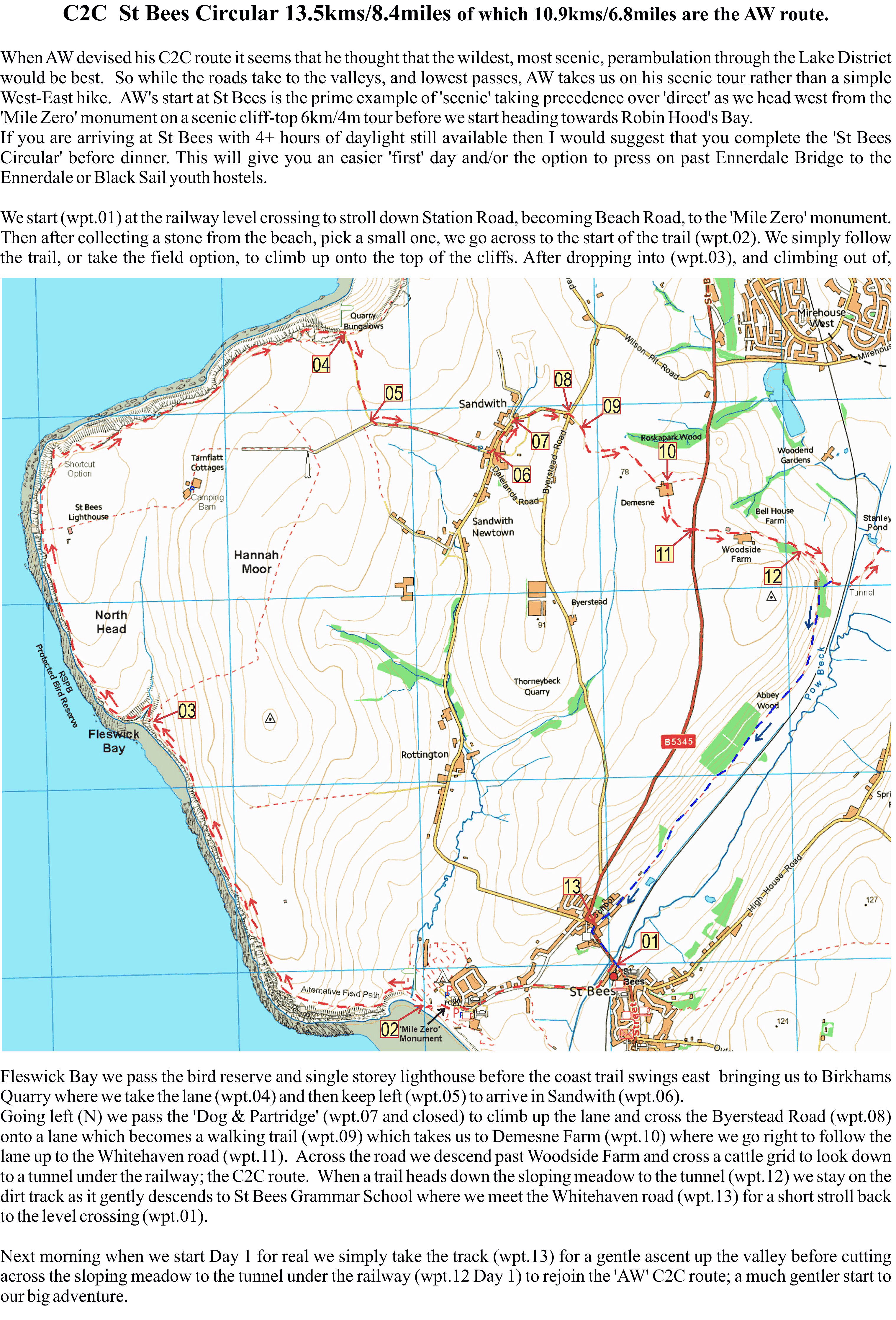
A sample page from the start of the adventure.David Brawn, author/researcher
For more information go to http://www.dwgwalking.co.uk/c2coast.htm
Spring! The Perfect Time Of Year For Walking In The UK
![]()
After a few false starts, it really is Spring in the UK. It’s a beautiful time of year to get out and about walking.
Here’s a bit of inspiration – the Brecon Beacons offer wonderful walking for everyone from leisure strollers to all-day-in-the-wild wanderers. Here’s a pic to whet your appetite, taken on route ‘Crib y Garth’ researched, recorded and photographed by author Bob Greaves who knows this area like the back of his hand.
This route climbs steadily up the Olchon Valley and returns along the narrow, most easterly, of the Black Mountain ridges which is popularly known as The Cat’s Back. The pic was taken half way along this ridge. It could be you in that landscape!
More info at http://www.dwgwalking.co.uk/brecon%20beacons.htm
Mallorca: Update on the GR221 – thanks Eryk Grant
These notes were sent by Eryk Grant re the GR221, while using Charles Davis’ book ‘The GR221 – Mallorca’s Drystone Way’
http://www.dwgwalking.co.uk/mallGR221Spec.htm , notably the stretch between Esporles and Valldemossa.
“Hi Charles
Walked this section last Sunday (6th April) without any problem.
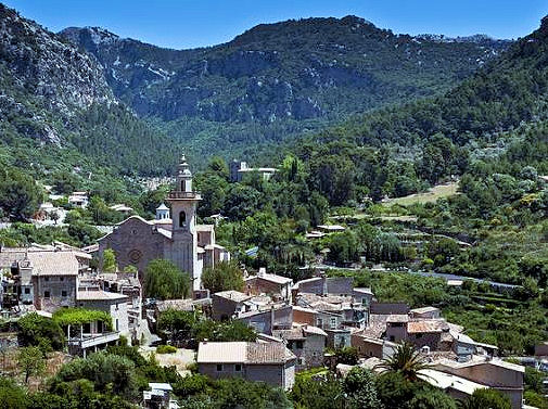
The Mallorcan town of Valldemossa
There were five other walkers on the route and it looks like the obstructions placed by the landowner (notices and fence) are largely ignored. I saw no attempt to ‘repair’ the fence and it was easy to negotiate-there are cairns galore and helpful green/yellow spots on rocks. The track has not become overgrown suggesting it is really well used. There is also a shiny new GR route map in Esporles town centre showing the route going through and all the subsequent wayposts except one refer to it. I guess there may be some tacit acceptance that walking will continue and I would not hesitate to walk this part again.
Up by the Tossals refuge there is a fair amount of building material but not much sign that anything is happening! Last time we stayed there in 2012 we had a conversation with a Dutch couple who were using your DWG guide, and making their way based on “what does Charles say?” – your directions and supporting commentary have never let us down either and in fact have really added to the enjoyment in places.”
Thanks Erik – feedback from walkers who’ve been there is valuable both for those who come after you, as well as providing us with valuable information for new editions.
Madeira: Good news – PR1 high altitude route re-opens
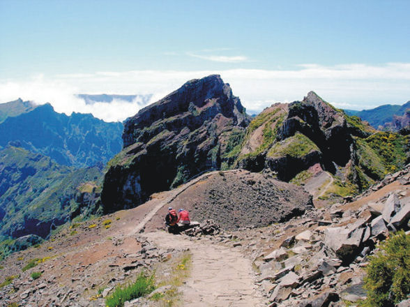
The route to Pico Ruivo
Madeira’s majestic high-level mountain route, the PR1 – Vereda do Areeiro to Pico Ruivo, has re-opened to walkers.
Landslides that had damaged the route have been cleared and fencing replaced.
This is the BIG one for high altitude afficionades!
(Image, thanks to Shirley Whitehead, walking researcher and author) – see http://www.dwgwalking.co.uk/mad.htm
Spain’s Costa Del Sol: Sierra Almijara + Sierra Tejeda = La Axarquia

Dramatic coastlines on the Torre Caleta walk.
Author/researcher Charles Davis sums up this beautiful, unspoilt region thus:
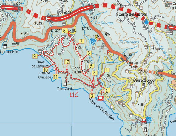
Map segment for the Torre Caleta walk.
“The Axarquía is one of Spain’s great places, and among the greatest places within it are the Sierras Tejeda and Almijara, which form the backbone both of the region and the present publication. Blessed with high summits, dizzying pinnacles, dramatic crags, deep ravines, dozens of springs, delightful rivers and the best coves on the Costa del Sol, this is an area that has something for everyone. And the only prerequisites for benefitting from all this are a desire to get off the beaten track and a set of relatively, sometimes very, sturdy legs.
If you’ve not seen them already, you can get an idea of how dramatic these mountains are from one simple fact, that the high peaks, including Lucero (1775 metres), Navachica (1832 metres) and La Maroma (2070 metres), are all within ten kilometres of the coast, rising out of the sea like a succession of immense pedestals, just waiting for humankind to enthrone whoever or whatever we find most sacred or simply most lacking in our quotidian lives.”

Axarquia; Las Cuadrillas, Walk 24.
You can see a sample walk here:- http://www.dwgwalking.co.uk/axarquiasamplewalk25.pdf
There’s information about the book Walk! The Axarquia (available as a printed book or as a pdf download book in A4 format) and the maps available for the region (printed, on paper and on Super-Durable material); there are also Custom Maps for Garmins for GPS users.
Walking the Yorkshire Dales – Just the Thing for Spring
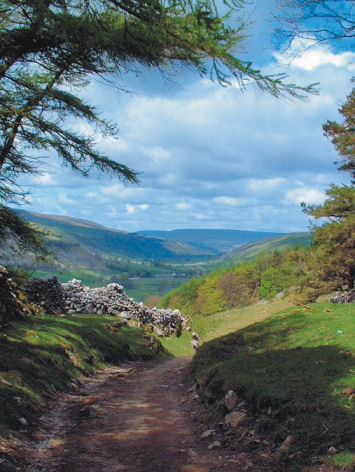
Wharfedale – following Walk 5

The village of Gayle, visited on Walk 25
The Yorkshire Dales is deservedly well-loved for its history, the beauty of its landscapes and its many unspoilt little stone villages, most with tempting pubs.
The best way to appreciate the Dales is on foot – and one of the very best times of year to do so is Springtime – right now!
If you have a Garmin GPS you can download Yorkshire Dales Custom Maps (there are two to cover the area) and get going on the trails.
For more information about the digital mapping for the Yorkshire Dales, see:- http://www.dwgwalking.co.uk/garminydalesnecustommap.htm
– and http://www.dwgwalking.co.uk/garminydalesnwcustommap.htm

The spectacular River Strid (Walk 1)
We recommend the book Walk! The Yorkshire Dales (North and Central) for the best walks (and the best pubs on route too)
See:- http://www.dwgwalking.co.uk/yorkshire%20dales%20N&C.htm
