
Dartmoor News – New research shows Sittaford Tor as Old as Stonehenge
 Did you see this interesting article in the Telegraph yesterday, 16 May 2015?
Dartmoor has a long and fascinating history; this new research suggests that some areas have an even longer history than was previously understood. See for yourself – take the walk.
The weather is perfect now for exploring British walking. If you want to take a look at the ancient stone circle of Sittaford Tor then follow Walk 9 in Walk! Dartmoor. The walk is a pleasant three and a half hour circular route which includes plenty of interest including the Tor.
For more information see:-
Read Discovery Walking Guides’ latest ENewsletter
Check out Discovery Walking Guides’ latest ENewsletter.
It’s packed with plenty of ideas for escaping winter to wonderful warm walking destinations, plus features on the Isle of Wight and Fuerteventura.
See it all http://ymlp.com/zK1jmu
Isle Of Wight Adventure Package – now released
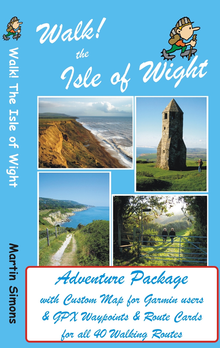
GPS users take note; our latest edition Walk! The Isle of Wight walks have been transformed into pdf route cards and re-packaged with ‘OSlike’ digital mapping for the Isle of Wight and gpx waypoints.
This is a great time to explore the Isle Of Wight; school holidays are almost over and there’s always the chance of some late summer sunshine.
Isle of Wight Adventure Package:-
Isle of Wight ‘OSlike’ Custom Map
gpx waypoints,
pdf ebook of 41 A4 pages
– all delivered as a ZIP file download for £11.99
See all the details here:-
Walk! The Isle Of Wight – new edition is here!
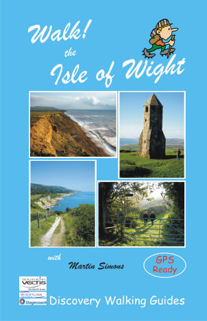 There’s no doubt that the Isle Of Wight is a wonderful place to visit and the best way to experience the island is on foot and by bus.
Walk! The Isle Of Wight (3rd edition) details 40 step-by-step walking routes, most accessed using public bus services.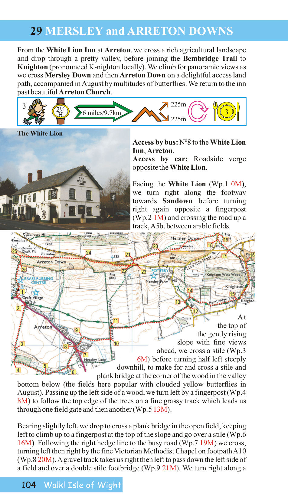
Each walk has its own colour OS Map, with the walking route and waypoints highlighted.
Here’s a sample page from the book so you can see what you’re getting:-
Good pubs (author tested) are recommended at the end of many of the routes.
See all the info here:-
Walk England Coast to Coast – a new approach to a classic adventure
 This classic route, pioneered by Alfred Wainwright, crosses northern England from – you guessed it – coast to coast. There are other books available – so what makes this one different?
Here’s what the author and researcher of this new take on a favourite challenge, has to say:-
“On a fortnight’s adventure with my mates Keith and Nigel from St Bees to Robin Hood’s Bay (July 2012) I talked to loads of C2Cers subtly asking what would make the route better. What everyone wanted was accurate navigation along the route, especially if it included ‘real time’ mapping.
There are loads of guide books about the Coast to Coast so rather than adding another book I have produced what every C2Cer wants:-
A system of accurate navigation for the whole route using ‘real time’ mapping on a Garmin gps or Viewranger phone app.
The result is a Stage by Stage guide, with alternatives, that gives you a real time mapping gps unit showing exactly where you are on the route along with the walking instructions that will ensure that you stay on the correct route.
On your Garmin, or Viewranger app, you will be on the right track every step of the way for all of the 198.5 miles (320km) from St Bees until you arrive at The Bay Hotel in Robin Hood’s Bay; where you will find the Wainright Bar with its C2C ‘sign in’ book.” David Brawn, author/researcher
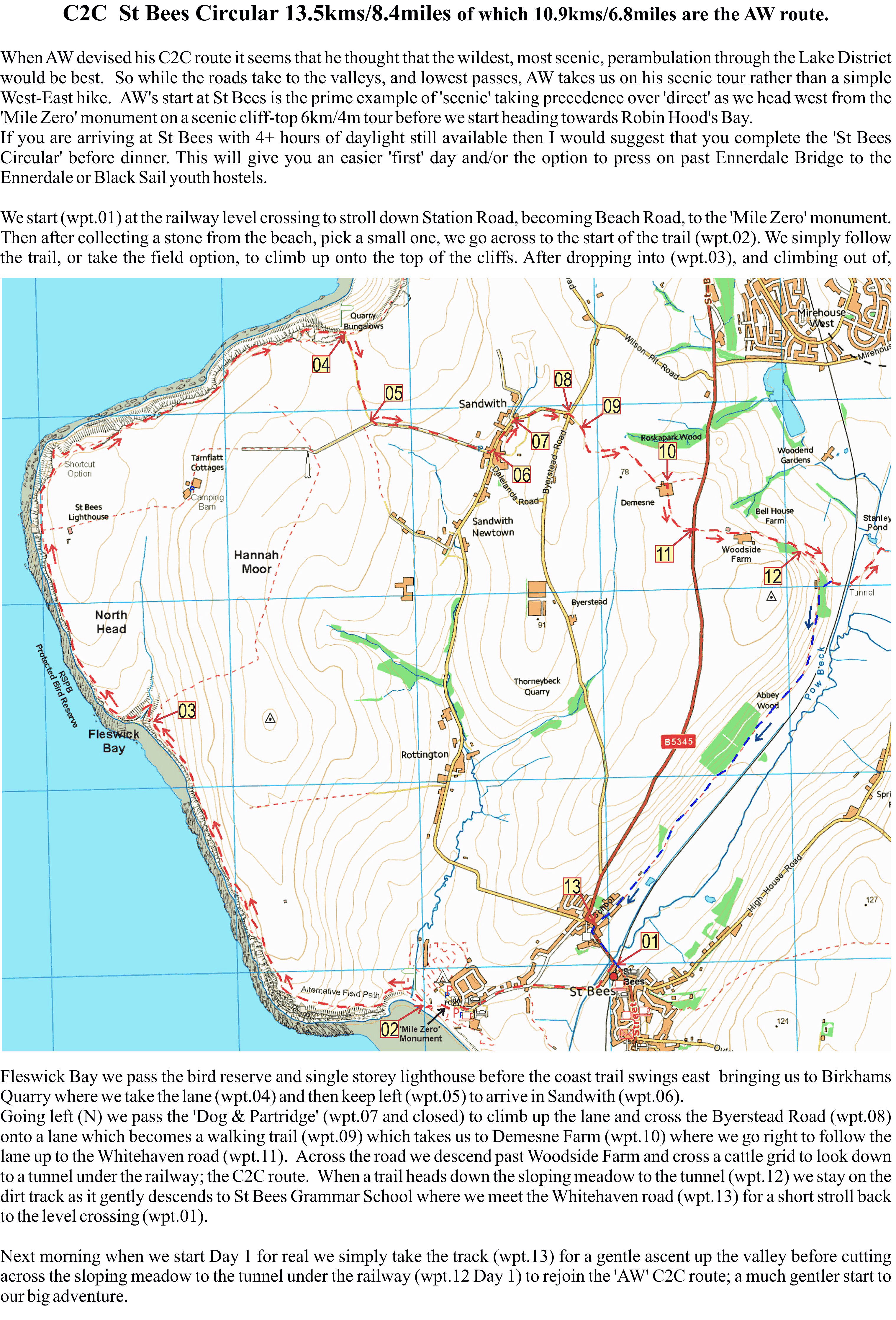
A sample page from the start of the adventure.David Brawn, author/researcher
For more information go to http://www.dwgwalking.co.uk/c2coast.htm
Spring! The Perfect Time Of Year For Walking In The UK
![]()
After a few false starts, it really is Spring in the UK. It’s a beautiful time of year to get out and about walking.
Here’s a bit of inspiration – the Brecon Beacons offer wonderful walking for everyone from leisure strollers to all-day-in-the-wild wanderers. Here’s a pic to whet your appetite, taken on route ‘Crib y Garth’ researched, recorded and photographed by author Bob Greaves who knows this area like the back of his hand.
This route climbs steadily up the Olchon Valley and returns along the narrow, most easterly, of the Black Mountain ridges which is popularly known as The Cat’s Back. The pic was taken half way along this ridge. It could be you in that landscape!
More info at http://www.dwgwalking.co.uk/brecon%20beacons.htm
Walking the Yorkshire Dales – Just the Thing for Spring
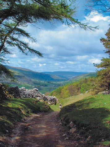
Wharfedale – following Walk 5

The village of Gayle, visited on Walk 25
The Yorkshire Dales is deservedly well-loved for its history, the beauty of its landscapes and its many unspoilt little stone villages, most with tempting pubs.
The best way to appreciate the Dales is on foot – and one of the very best times of year to do so is Springtime – right now!
If you have a Garmin GPS you can download Yorkshire Dales Custom Maps (there are two to cover the area) and get going on the trails.
For more information about the digital mapping for the Yorkshire Dales, see:- http://www.dwgwalking.co.uk/garminydalesnecustommap.htm
– and http://www.dwgwalking.co.uk/garminydalesnwcustommap.htm

The spectacular River Strid (Walk 1)
We recommend the book Walk! The Yorkshire Dales (North and Central) for the best walks (and the best pubs on route too)
See:- http://www.dwgwalking.co.uk/yorkshire%20dales%20N&C.htm
Worth A Read – article on the Isle of Wight in the Weekend Telegraph

Expansive views on Week Down (walk 27, Walk! The Isle of Wight)
There’s a good article on the Isle Of Wight in ‘Coastal England’, a supplement with yesterday’s (15 March 2014) Weekend Telegraph.
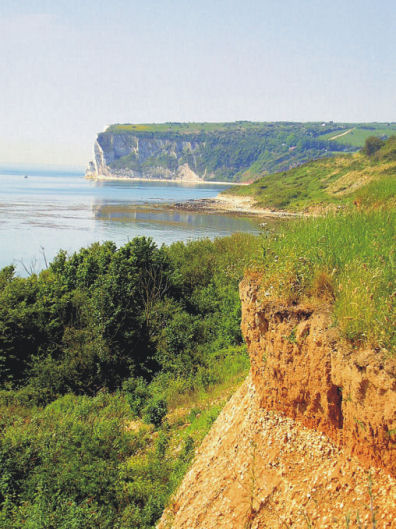
Looking towards Whitecliff Bay from the clifftop path (Walk 40, Walk! The Isle of Wight)
The article homes in on the rich history of the island and offers plenty of ideas of things to do. For such a small place it has a wealth of festivals, including the Isle of Wight Walking Festival.
Find it here: http://www.telegraph.co.uk/sponsored/travel/visit-england/10676115/things-to-do-on-the-isle-of-wight.html
For details of walking there see http://www.dwgwalking.co.uk/isleofwight.htm
For information on mapping look here: http://www.dwgwalking.co.uk/garminisleofwightcustommap.htm
Exmoor – wonderful walking and now OSlike Custom Maps too
Wonderful walking in Britain’s Exmoor!
Here’s just one splendid view overlooking Lynton and Lynmouth while following Walk 16 from ‘Walk! Exmoor’ with David and Carol Hitt. For more information about walks here, see : http://www.dwgwalking.co.uk/exmoor.htm
And now – for Garmin users – download OSlike Custom maps for Exmoor, overlaid with the 40 varied routes from Walk! Exmoor.
OSlike Custom Maps can be used in Google Earth, Garmin Basecamp and Garmin gps units.
There’s east and west sections to download, (£3.99 each) which can be found here: http://www.dwgwalking.co.uk/garminexmoorecustommap.htm
and here: http://www.dwgwalking.co.uk/garminexmoorwcustommap.htm
OSlike Brecon Beacons Custom Maps for Garmin
Ready now to download – Brecon Beacons West and Brecon Beacons East OSlike Custom Maps for Garmins.
For details and how to download, see here:- http://www.dwgwalking.co.uk/garminOSlikemaps.htm
