
La Gomera – New Ferry Services Make Adventuring Easier
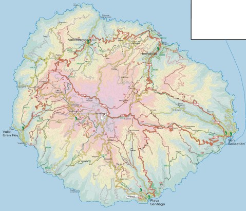
Simplified map of La Gomera by kind permission of David Brawn
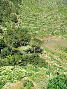
La Gomera is a remarkable, almost circular island, a hop away from Tenerife, (Canary Islands) which rises like a giant cake to central forest-cloaked rugged heights, cut by barrancos (ravines) running to the sea. The island is still largely unspoiled which makes it a wonderful destination for hikers and bikers, though getting around takes time as there are few roads. If you don’t wish to get too energetic, simply amble about, dropping into cafés and fish restaurants and breathing in the pure air and beautiful views, enjoying the contrast between this quiet island and its busier big sister Tenerife.
This makes the introduction of not just one but two new sets of ferry services opening up some of the island’s best coastal towns really interesting. You could, for example, take the new car ferry Volcán de Teno from Tenerife’s Los Cristianos at 08.45 and be in Valle Gray Rey 90 minutes later, making a day out in this wonderful ‘Great King’s Valley’ feasible, heading back to Tenerife on the 16.30.
For all the details and to make a booking, see Naviera Armas website.

San Sebastian, La Gomera
It’s around five years since three of La Gomera’s most interesting and important coastal towns were linked by ferry services.
Now Fred Olsen has begun 3 services per day (becoming known as the ‘interior ferry line’), linking San Sebastián, Playa de Santiago and Valle Gran Rey, aboard the Benchi Express. If you’re starting from Tenerife you can do the first ferry hop from Los Cristianos. The Benchi can take bicycles, light motorbikes and pets! It also has a small cafeteria and is wheelchair accessible.
For details of the Fred Olsen services, look HERE.

La Gomera – in the south -Tenerife’s Teide visible

Valle Gran Rey
If you’re starting from Tenerife you can do the first ferry hop from Los Cristianos. The Benchi can take bicycles, light motorbikes and pets! It also has a small cafeteria and is wheelchair accessible. Take a look at their website for all the details and to book.
There’s a well- informed and highly readable blog with more La Gomera travel information here.
MAPS AND WALKING GUIDE BOOKS FOR LA GOMERA
For information about large-scale maps, digital mapping information and walking guidebooks, take a look HERE.
Who got a Garmin for Christmas?
If you are one of the many who found a Garmin GPS in their Christmas stocking, this post is for you.
Get your hands on a free sample ‘real-time’ map and see your Garmin come to life. You can choose a sample map of Graciosa ( off Lanzarote, Canary Islands) or Sierra de Aracena (Andalucia, Spain).
What you’ll get is a highly detailed real-time Tour & Trail digital download map, which you can save on your hard drive, transfer to your Garmin GPS CustomMap memory or onto a micro-SD card; you can also use the maps in Garmin Basecamp and Google Earth.
CANARY ISLANDS
Sample segment, Gran Canaria.
Gran Canaria
Tenerife
La Palma
La Gomera
Lanzarote
Fuerteventura
MAINLAND SPAIN
Alpujarras (Sierra Nevada, Andalucia, southern Spain)
Costa Blanca Mountains (Alicante, southern Spain)
Axarquia (Andalucia, southern Spain)
Sierra de Aracena (Helva province, southern Spain)
BALEARIC ISLANDS
Mallorca
Menorca
Formentera
Ibiza
PORTUGUESE ISLANDS
Madeira
For more information about Tour & Trail Maps take a look HERE.
Are You Off To Walk Madeira? Check Before You Walk.

Aloe aborescens clinging to Madeiran cliffs
Madeira! What a great desination, especially at this time of year.
Swapping the dark and cold of Northern Europe for Madeira’s green and spring-like mountains is a popular choice at this time of year.
If you are planning to walk there, it’s worth checking that the paths you’re planning on following are open. The best place to look for information is on the official ‘Visit Madeira’ tourism website. To see which routes are open or temporarily closed, LOOK HERE.
If you are already on the island, you can also ask in Tourist Offices who usually have up to date information on walks that are open/closed.

A spectaculat waterfall on the Levada da Ribeira da Janela
At the moment only three of the official routes are temporarily closed. The authorities are vigilant and usually restore routes quickly; often, the problem is a landslip after heavy rain.
The three routes to avoid at the time of writing this are:
PR1 – Vereda do Areeiro
Temporarily closed
PR12 – Caminho Real da Encumeada
Temporarily closed
PR19 – Caminho Real do Paul do Mar
Temporarily closed

Levada Nova, Madeira
There’s so much great walking on Madeira that you’ll find plenty to tempt you, from strolls to all-day high altitude challenges. Even if you aren’t keen to do much walking, it’s a great idea to use the local buses which give you brilliant (sometimes a bit hairy!) adventures around the island for pocket-money prices.
There’s a great bus map available, also really useful as a driving map; LOOK HERE for details of the Madeira Bus & Touring Map.
For more information including details our two Madeira Walks guidebooks Madeira Tour & Trail Map and digital mapping for Madeira, take a look at Discovery Walking Guides; Madeira pages.
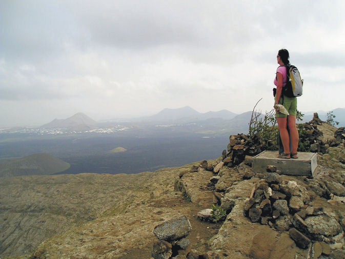
Lanzarote; rains bring the desert to colourful life!
Barranco del Malpaso, Lanzarote
Residents on the Island of Lanzarote tell us that more visitors than usual have been enjoying the great outdoors on this unique island during November and December this year. The dramatic volcanic landscape is unforgettable, though is usually desert-dry with little natural green to see.
It doesn’t rain much (or often) on this arid Canary Island, so recent falls have been most welcome, bringing colour and plant life back to otherwise arid areas.

Helechos, Lanzarote
What a great time to visit! Warm days and sunshine (average of six hours per day in December, even more in January), plus the chance to see the colourful green swathes and flower carpets that happen for only a few weeks each year. Walk, hire a bike or car, or jump on a bus.
La Geria, Lanzarote
There’s plenty of interesting information about the island on the Lanzarote Information website; use the link below.
Take a look at the really useful Lanzarote Information website.
For more on this fascinating and often surprising island, including printed and digital mapping and walking information, take a look here:-
Montaňa Corona, Lanzarote
Choosing A Winter Walking Destination
What do you need for an enjoyable walking holiday when winter closes in on the northern hemisphere?
RELIABLE WARMTH AND SUNSHINE

On La Gomera – Tenerife’s Teide visible
A 5 hour flight south (from the UK) gets you to the Canary Islands, off the coast of Africa. You can expect about six hours of sunshine per day (average) with highs of 20C in December though of course there are variations depending on the island and location.
Levada Nova, Madeira
Madeira is a bit closer and almost as sunny (around 5 hours) and almost as warm though the chance or rain is higher. That’s why Madeira is so green and floriferous!
A GOOD CHOICE OF HOTELS, NIGHT LIFE, SHOPS and RESTAURANTS
The Canary Islands and Madeira don’t really have a ‘closed’ season for tourism so you will find a wide range of accommodation, eating places, shops and night life. There are quieter, smaller places to stay if you want to get away from the ‘bright lights’.
EASY TO GET TO
There are plenty of flights all year round to the Canaries and to Madeira.
WHAT’S THE WALKING LIKE?
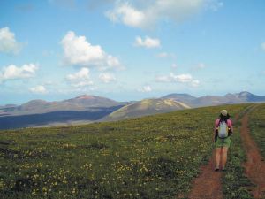
Each of the Canaries is unique, offering a wide choice of walks and challenging hikes. If you are looking for a pleasant stroll for an hour or two, a coastal discovery route or a full day in the mountains (or something inbetween), the Canaries are an ideal choice.
Madeira is rugged and steep, though the many levada walks (mostly level walks alongside narrow water canals) make it a walking destination with plenty of choice for all.
FIND OUT MORE ABOUT CANARY ISLANDS WALKING HERE:-
FOR MORE ABOUT WALKING ON THE GARDEN ISLE OF MADEIRA, LOOK HERE:-
Madeira
Gran Canaria, Canary Islands – New 3rd Edition Tour & Trail Map
It may not be as well-known as some of the other Canary Islands – that means there’s plenty of room for you to explore this bold, beautiful and dramatic island.
You want mountains and ravines? You want remote, unspoiled sleepy villages? You want abundant verdant woodlands, paths and tracks? You want endemic plant life found nowhere else? You’ve got them all on the island of Gran Canaria.
Map section, Gran Canaria
This third edition includes new walking routes, even clearer ways to show routes and other map features and all the detailed cartographic information that afficionadoes of the Tour & Trail series have come to expect and rely upon. Take a look at this small extract (left).
Detailed updating and addition of new walking routes and additional data have been researched by our ‘on the ground’ walking expert, ‘Rambling Roger‘ and his fellow walking researchers who know the island like the backs of their hands.
If you’re looking for an adventure away from the European winter, with almost guaranteed good weather and great walking (definitely guaranteed) then take a look at Gran Canaria.
(Custom Map digital edition for Garmin Users is available from Discovery Walking Guides’ website. Digital editions are available for 3G/4G GPS apps from Viewranger and My Trails.
Walking Newsletter Now Available
Take a look at Discovery Walking Guides latest newsletter; topics include Menorca, Lanzarote, free digital maps and Walk! books and more. Click the link to read all about it.
Formentera? Where’s that? UPDATE
You’d be forgiven for not knowing the location of this little gem of an island. It’s surprisingly easy to reach and has a delightful personality all its own.
Formentera is one of the Balearic Islands to the east of mainland Spain, in the Meditteranean. It’s the little sister island to Ibiza and is only a 30-minute ferry trip away.
Here’s a few facts and figures:
- Beaches, beaches – so many of them for such a small island and white, clean and beautiful.
- The island had been occupied by the Carthaginians, then the ancient Romans, the Visigoths, the Byzantines, the Vandals, and the Arabs.
- Eventually the island added to the Crown of Aragon and later became part of the medieval Kingdom of Majorca.
- The main island of Formentera is 19 kilometres (12 miles) long and is located about 6 kilometres (4 miles) south of Ibiza in the Mediterranean Sea.

San Francesc, Formentera
- The major villages are Sant Francesc Xavier, Sant Ferran de ses Roques, El Pilar de la Mola and La Savina.
- Formentera comprises one municipality, also called Formentera, and has a population of 9,962 (as at 1 January 2010).
- Its land area is 83.24 square kilometres (32.1 sq mi).
- Cars are easily hired in the port and there’s a good choice of conventional or electric vehicles. There are more electric vehicle charging points here than anywhere else in the world, given its land area.
- Mopeds and bicycles are available to hire; the terrain is mostly flat and there are dedicated cycle lanes in some areas.
- The island has four Martello towers.
- Ferries to Formentera from Ibiza operate every half hour in high season.
- A local Ibizan (eivissenc) variant of the Balearic dialect of the Catalan language is spoken in Formentera though English and other European languages are frequently heard too.
Discovery Walking Guides carried out an intensive cartographic survey on Formentera a few weeks back and design of the new Formentera Tour & Trail Super-Durable Map is well under way.
For full details about the new Formen tera map, click here.
KICKSTARTER PROJECT
How would you like to be part of the launch of this exciting new map project? For a modest pledge you can help this project to fly – and receive free maps too.
There’s still time to be a part of this exciting project.
Take a look at DWG’s Kickstarter Project here.
Ibiza – white beaches, azure seas, verdant pine forests UPDATE
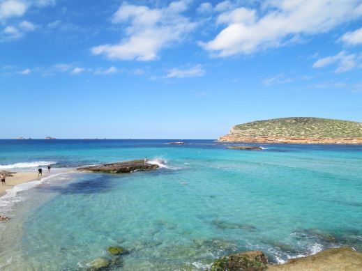
Forget the tabloid image of all-night clubbing, loud music and young visitors in various states of inebriation and undress.
The real Ibiza is a beautiful place, blessed by a wonderful climate with many hours of sunshine each month.
Numerous fine white beaches and little coves tempt the swimmer and sun-worshipper, while walking/biking trails meander through wild flowers underneath a canopy of fragrant pine woods.
A few Ibizan facts:
- Ibiza is one of the Balearic Islands, in the Mediterranean east of the Spanish mainland.
- It’s a naturally beautiful island with white sand beaches, turquoise seas and verdant pine woods, olive groves and wild flowers.
- The island has a long history of invasion by various forces including the Ancient Romans, the Vandas, Byzantines, the Moors, the Norwegians and were finally claimed by Spain. Nowadays, the ‘invaders’ are tourists.
- Ibiza is 572.56 square kilometres (221.07 sq miles) land area.
- The highest point of the island is Sa Talaiassa, at 475 metres (1,558 ft).
- The population is estimated at approximately 132,500.
- Eivissenc, a dialect of Catalan, is spoken on Ibiza, as is Spanish. English is widely spoken in tourist areas.
- Though renowned for its clubbing scene, there are beautiful beaches, pine woods and walking/biking routes across the island.

One of Ibiza’s beautiful coves (on the west coast)
Until now, the maps available for the island of Ibiza have been basic and without the kind of detail you need to enjoy exploring.
That’s all set to change as Discovery Walking Guides has completed their ‘on the ground’ mapping survey. Design of the new Ibiza Tour & Trail Super-Durable Map is well under way.
Click HERE for all the details of the new Ibiza map.

KICKSTARTER PROJECT
How would you like to be part of the launch of this exciting new map project? For a modest pledge you can help this project to fly – and receive free maps too.
There’s still time to part of this exciting project.
Take a look at DWG’s Kickstarter project here:
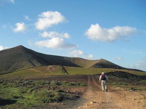
Lanzarote – walking the Caldera Blanca

Wow! The interior of the crater, Walk 39, Lanzarote.
Our thanks to Robert and Penny, recently returned from walking on Lanzarote. Here’s what they told us:-
Standing on the volcanic crater rim of Caldera Blanca, Lanzarote.
We have just returned from 10 days walking in Lanzarote. Your book was a great help as there is little in the way of signs or clear path markers. Without your book we would have frequently got on the wrong
route.
One comment, on walk 39, Caldera Blanca, We agree this was a
fantastic walk and the view from the crater rim were fantastic.
However, if we were to do this walk again we would have gone round the
other way (anti clockwise). The decent from the top was much steeper
and the path was full of small stones which required great care to
safely negotiate. We would have been much happier going up that way.
We walked in La Palma a few years ago and again found the guide great.
Thanks again for a great guide.
Robert and Jenny P
