
La Gomera – thanks to ‘Inspire Our Trip’
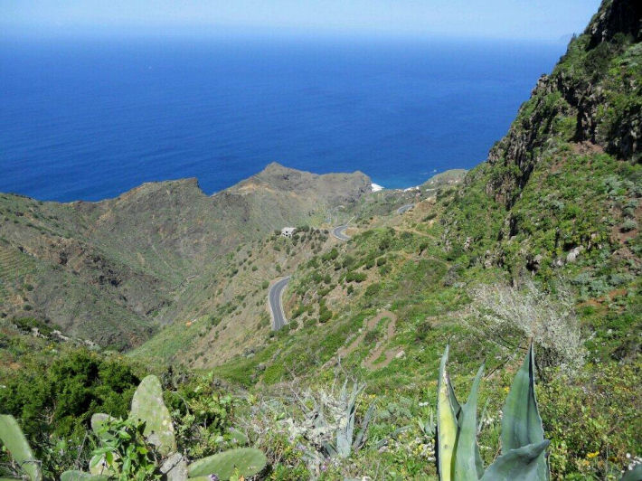
La Gomera – on Walk 31 (from Walk! La Gomera by Charles Davis). Image courtesy of ‘Inspire Our Trip’.
‘Inspire Our Trip’ on twitter said:-
“Brilliant hike and a great day walk. Thank you Charles Davis for Walk 31.”
Charles Davis is the author of Walk! La Gomera:- see http://www.dwgwalking.co.uk/walkla.htm
https://twitter.com/InspireOurTrip/status/455766577577988096/photo/1
Lanzarote Report (and what’s a thingy?) – thanks, John and José
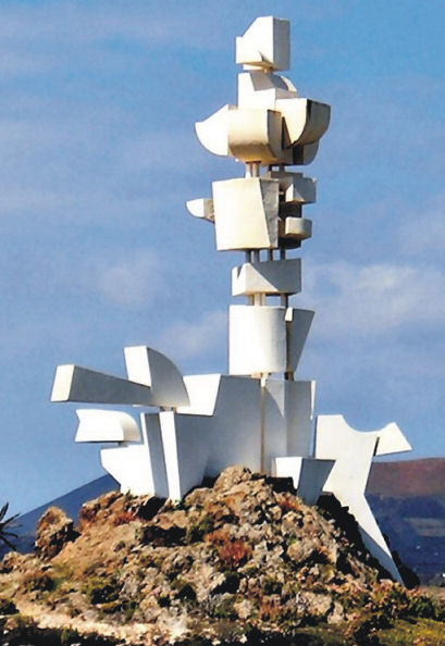
Manrique’s Monument to the Campesino Thingy
John and Jose sent this great email after their walking holiday on Lanzarote. Their comments about the Lanzarote ‘Thingys’ raised a smile!
5 April 2014
Hi there,
We just like to say how helpful the walking guide for Lanzarote (Walk! Lanzarote) has been to us.
We’re just back from this gorgeous island and `did lots of walks from the guide.
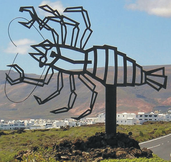
Lobster Traffic Island Thingy
At times that we lost our way or got confused, it was always our own fault, misreading or misinterpreting the directions. In hindside we’d say: “it was actually in the guide!” and “Yes, they did warn us it might be confusing”.
We also enjoyed the humour in the guide. It was like having the writers winking at us, giving us encouragement.
We had some trouble with the name ‘Thingy’ for all the sculptural-roundabout-objects, but could not come up with a better name either, so

Lanzarote Toast Rack Thingy
Thingy it will be now for us too 😉
Best of luck with future guides, we will definitely look for one again on our next walking
holiday.
Kind regards, John and José (Wicklow, Ireland)
9 Hours of daily sunshine in March? 22C tomorrow? It’s Gran Canaria, right now!
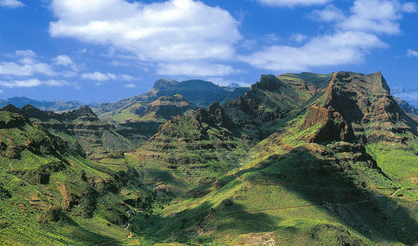 They don’t call it the ‘mini-continent’ for nothing!
Though it’s under a 5 hour flight away (from the UK and western Europe) it feels like a different world.
There’s plenty to see and do, though the best thing of all is to walk the trails and marvel at the views, the forests, flora and fauna and the ancient villages.
 Discovery Walking Guides launched their Gran Canaria Tour & Trail Super-Durable map only a week ago, and the demand has been exceptional. It certainly looks as if Gran Canaria is emerging from the shadows to become this year’s ‘must walk’ destination in the Canary Islands.
There’s wonderful dramatic scenery and unspoilt villages, plus clean, spacious beaches for the days you don’t want to walk (or bike or drive).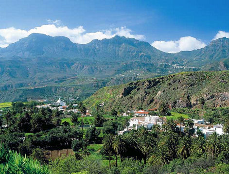
To find out more about the map look here: http://www.dwgwalking.co.uk/gcan.htm
There’s plenty of walking information from Rambling Roger who lives there and knows the island like the back of his hand; look here: http://www.ramblingroger.com/
If you fancy 22C and nine hours of sun in March, hop over to Gran Canaria.
Gran Canaria – what a destination! And The Gran Canaria Tour & Trail Super-Durable Map is Here!
Never been? This is one of the less-visited Canary Islands but that could be set to change. The digital version of Gran Canaria Tour & Trail Map has been available for a few weeks – now comes the Super-Durable printed version. For more information see: http://www.dwgwalking.co.uk/gcan.htm
Go soon before the summer visitors arrive and have those wonderful mountains and ancient walking trails just about to yourself.
Rambling Roger knows the island like the back of his hand – see his website here: http://www.ramblingroger.com/hiking_maps/index.html
7 Hours of sun a day in February? That’s Lanzarote For You

The Haria region, Lanzarote
It’s little wonder that Lazarote, part of Spain’s Canary Islands, is so popular as a winter escape. Even in February, there’s an average of seven hours of sunshine a day.
The image (right) was taken on a walking route in Haria, in the island’s north.This region receives the lion’s share of rainfall which, added to the rich volcanic soil, makes for an area rich in wild and endemic plant life.
Want to see a sample route? Click here for a pdf download of http://www.dwgwalking.co.uk/lanzsamplewalk26.pdf

Walk! Lanzarote as a pdf download.
And if you like that, there’s an entire book-full of 39 walks complete with full descriptions, maps and images for £4.99 to download http://www.dwgwalking.co.uk/lanzWalkSpec.htm
La Palma Updates 11 Feb 2014 – thanks to Chris S
Our thanks go to Chris S who has just sent us his observations after using Walk! La Palma on the island:- 
From: Chris S
Date: Tue, Feb 11, 2014 at 1:56 PM
Walk 1 : Coming from the west, there is now a turn-off just before the tunnel, which leads to the LP301 (presently in a very poor state of repair, like most of the island’s roads).
Walk 6 : The walk starts just west of Centro de Visitantes de El Paso (Caldera de Taburiente also prominently displayed on the building).
Walk 7 : Descent from Birigoyo now starts with some tight, but easy zig-zags where there is insufficient grit or steepness to skitter. It’s not until you get down to the crater that you encounter a few inches of grit underfoot.
Walk 10 : Walking the rim of San Antonio crater now 5 euros pp. You might be able to sneak past the ticket office if you ignore the sign forbidding pedestrian access to the car park from the Fuencaliente side, but you have to present tickets to the young lady at the entrance to the visitor centre : the only realistic gateway onto the path. There is now chain fencing along the rim and on the narrower bit, it’s on both sides of you.
Walk 14 : The road up to El Pinar was surprisingly the best surface we drove on and the tarmac now extends further than the start point.
Walk 20 : Where the narrow tarmac lane taken at wp2 bends to the right in less than a minute, a waymarked path heads off to the left, rejoining the lane just above wp3. According to the signpost at wp2, the distance to Don Pedro is 6.n km.
Walk 30 : There are 2 signs to Pico de la Nieve on the track by the start of the walk, but they don’t indicate distance.
Walk 32 : The track leading to the car park at start of walk is now only suitable for 4WD, imo. Most of the hire cars which attempt it ,don’t make it all the way. The alternative signposted, but not waymarked, route to/from the ridge is very worthwhile. It involves a little bit more ascent and is a bit longer, but there are several points where different aspects of the peak and caldera are seen. Shortly after the last signpost : ‘1400 metres to Pista de Valencia’, the track forks and it’s the left branch, which soon dwindles to a path that leads more directly to the tarmac.
I’m going to write a review on amazon to emphasise the practical superiority of your guide over *********. I will certainly be buying your guides to the other Canaries, rather than wasting money on “updated” versions of **** ********* efforts, good though they were at the time they were written.
Regards,
Chris
La Gomera Update – thanks to Terry
It’s in the nature of walking trails that they may become impassable (usually temporarily) due to landslides, flood damage or forest fires. The good news is that nature and/or man usually repair the route before long.
Terry M just sent us this update which affects Walk 13 on the island of La Gomera:-
On 10 February 2014 Terry M wrote:
Hi,
We tried Walk 13, La Gomera but had to abandon it. A forest fire has made it impossible to follow the directions between waypoints 7,8,9 and 10. The trees are unrecognisable and the path obliterated. Herbs, mostly Cistus, have grown over the whole area and the donkey trail is unrecognisable. Even with GPS we could not find the way and had to retreat to the road.
Regards,
Terry
Get Away From Winter – there’s wall-to wall sunshine now in La Palma
If you’re in the UK or northern Europe you have most likely had enough of gales, floods and dark skies. On the teardrop-shaped volcanic island of La Palma, Canary Islands, the forecast ahead is for almost wall-to-wall sunshine with daily highs of 20-22C and not much less than 16C in the night.
Even better, it offers dramatic and wonderful walking. And you could be there within 5 hours’ flight time from UK and many European airports.
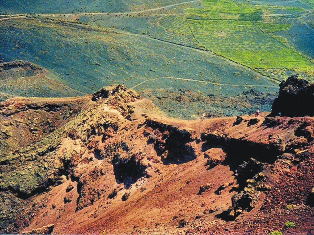
The image (right) was taken while following the Ruta de Los Volcanos.
And how about following the route of the southern volcanoes (left)? Much of the walk is along the volcanic ridge that bisects the island west-east, offering super views. Here’s how it looks on the La Palma Tour & Trail Map.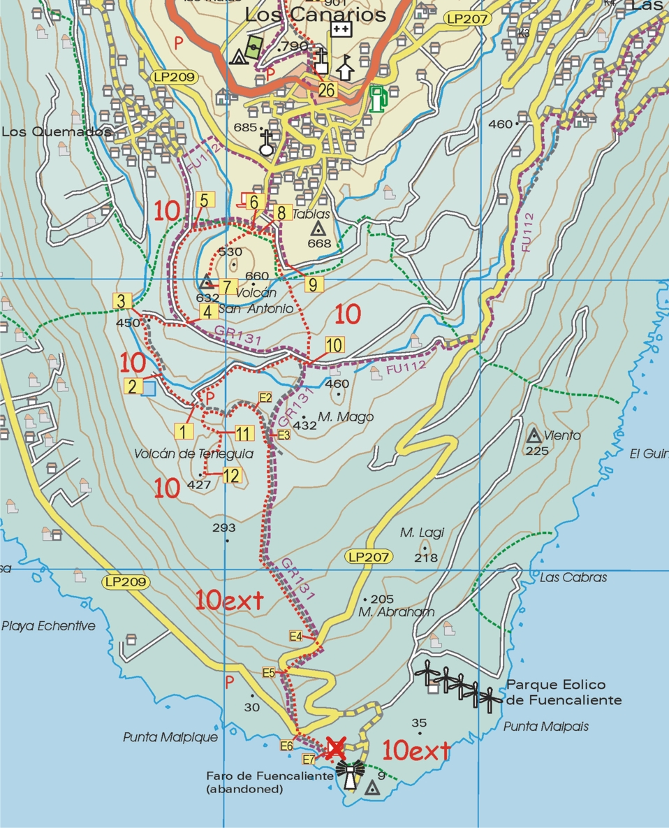
 The image below shows a walker starting out on the Roque Palermo route; La Palma’s famous observatory can be glimpsed in the background.
There’s more information here:- http://www.dwgwalking.co.uk/lap.htm
A Taste Of La Gomera’s beauty – a free walk to download
 You’ve heard of Tenerife – but where’s La Gomera? It’s just a short ferry ride from Tenerife yet as different as chalk from cheese.
The island is almost circular and resembles a giant cake cut again and again by dramatic barrancos (ravines) running from centre to sea, topped by an ancient and mysterious laurel forest.
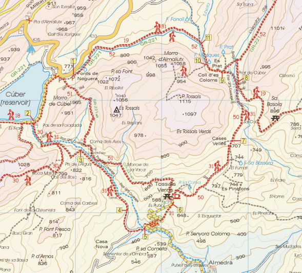
The taster route is Walk 26, ‘Las Mimbreras’, offering a tantalising sample of the island’s adventures. Here’s a map section of the route.
Find your free walk here:- http://www.dwgwalking.co.uk/walkla.htm
Tenerife – How About A Free Sample Walk?
 Here’s a great idea – download a free sample walk taken from Walk! Tenerife. You’ll get the full walk description, mapping and images. There are 46 walks in the book, covering the island’s best walking areas.
Your free download is Walk 41 ‘Las Mercedes – Llano de Los Loros’. Our pic shows one of the great views from the route, over the Tahoido Dam and down to Tenerife’s north coast.
Here’s the link you need to access your free download; print it out on one sheet of A4 or save the pdf to your computer:- http://www.dwgwalking.co.uk/ten35walks.htm
